Preliminary Documentation for Changes/Additions in SP1.8.0
- 1.9.9.1
First thing, warning about various versions and loading. The configuration
data structure has changed in this version so it will reset that data when
you load it over the top of a previous version. However, with the addition
of reading and writing data from DOC, Memo and Flash Cards, upgrading is now
much easier. Please use the following instructions when upgrading: READ
THIS BEFORE LOADING!!!!
If you have:
- Version 1.71 or earlier loaded.
- First time you run this version, all configuration including flights,
waypoints and polar info will be RESET.
- You cannot load a previous version's config file into 1.8 or later
as it is not formatted correctly for this version.
- In some cases, the reset has not been successful with various problems
resulting.
- If you run into any problems after install, please remove the program
from your PDA and then reinstall the new version. This will definitely
reset all the configuration
- Version 1.8 thru 1.83 installed:
- The Waypoint, Flight Log, Task and Configuration
databases have changed. All of these databases will be reset when
this version is loaded. So please output any
unsaved logger info before loading.
- If you want to upgrade the current configuration info, load version
1.8.7 first.
- Use the new data output options added in 1.8.7 to output the configuration
info to Memo, DOC or Flash Card.
- Load this version which will reset the configuration information.
- Read the configuration info back in from Memo, DOC, or Flash Card.
- Version 1.84 thru 1.9.7 installed:
- The Waypoint, Flight, Log, Task and Configuration
databases have changed.
- If you have 1.84 through 1.8.6 loaded and want to upgrade the current
configuration info, load version 1.8.7 first (if not already installed).
- Use the new data output options added in 1.8.7 and above to output the
configuration info to Memo, DOC or Flash Card.
- Load this version which will reset the above information. Read the configuration
info back in from Memo, DOC, or Flash Card.
- Version 1.9.8-1.9.9 installed:
- You can load 1.9.9.1 over 1.9.8-1.9.9 without a problem.
So much for the warnings....now for the cool stuff.
Version
1.9.9.1
includes
the
following
new
features
and
fixes:
- Problem with Metric Conversion of Waypoint Additional Info Screen
- Fixed a problem where the runway length on the Waypoint
Additional Info screen was not converting/display the lenght correctly when
configured for Metric units. The units for the runway length will now be
tired to the "Distance" units value. If you have Statue or Nautical
miles, you will get the length in feet. If you are using Kilomters, then
you will get meters.
Version
1.9.9
includes
the
following
new
features
and
fixes:
- Waypoint Additional Data Problem with Manual New Waypoint
- If you added a new waypoint from the moving map the
Additional data fields were not being initialized properly. This has been
fixed now.
- Declared Task vs. Active Task - When a task is activated,
an input window will be displayed asking if you also want to Declare the
current task as well. If you select Yes to this, the current task you
are activating will become the task that will be outputted with the flight
info of the next/current flight. If you say No, then the previous declaration
information will be retained and outputted with the flight. This allows
you to have one task that was previously "declared" (perhaps prior
to your flight) and then change the active tsk to be something else entirely.
Version
1.9.8
includes
the
following
new
features
and
fixes:
- Garmin
iQue
Sim
Mode
Support
-
Added
a
"Garmin
Sim"
checkbox
that
shows
up
on
the
NMEA/Config
screen
to
allow
user
to
make
the
software
accept
data
when
the
iQue
is
in
simulation
mode.
This
option
defaults/resets
to
off
when
the
program
starts.
-
Cleaned
up
the
small
vertical
line
that
remains
when
the
Final
Glide
page
status
changes
from
NO
GPS
or
NOSATS
to
an
active
state.
- Mixed
Borgelt
B50/Colibri
Computer
Type
-
New
Computer
type
of
mixed
B50
and
Colibri.
Had
to
move
picklists
around
on
the
NMEA/Port
screen
a
bit
to
make
room.
If
this
type
is
selected,
it
parses
the
proprietary
NMEA
data
from
both
units
and
uses
the
information
as
appropriate.
-
Fix
for
Lift
calculation
-
If
Use
Palt
was
selected
but
an
alt
src
other
than
GPSAlt
was
selected,
would
result
in
no
lift
calc.
- Made
the
Alt
types
change
automatically
if
C302,
Colibri
or
the
B50/Colibri
computers
were
selected
-
Can
still
be
changed
after
this
to
something
else
though.
- Fix
for
Treo
600
Users
-
It
seems
that
when
Handspring
(now
PalmOne)
went
with
PalmOS
5.0
they
did
away
with
the
call
to
disable
their
keyboard
daemon.
However,
that
was
the
call
that
was
causing
problems.
I
had
to
make
the
checking
a
bit
more
picky
so
that
it
will
not
try
to
disable
it
if
running
on
a
Treo
600
or
more
correctly,
a
PalmOS
5-based
Handspring
model.
- New
North
Up
and
Course
Up
Map
Modes
-
You
may
now
select
from
three
different
map
orientation
modes
on
the
Map
settings/config
screen.
The
modes
are:
Track
Up
-
This
is
the
current
orientation
method
where
the
glider
does
not
rotate
and
the
rotates
as
your
heading
changes.
North
Up
-
Magnetic
north
is
always
at
the
top
of
the
screen
and
the
glider
symbol
turns
as
your
heading
changes.
Course
Up
-
If
you
have
a
waypoint
selected
or
using
an
Active
Task,
the
direction
current
waypoint/turnpoint
will
always
be
at
the
top
of
the
screen.
If
this
mode
is
selected
but
no
waypoint/turnpoint
is
selected,
it
will
then
use
the
North
Up
mode.
In
addition
to
being
able
to
select
the
mode
from
the
Map
settings/config
screen,
you
can
also
switch
the
current
mode
from
the
Moving
Map.
Simply
touch
the
Map
Radius
value
are
and
it
will
toggle
between
the
three
modes.
Note:
The
North
Up
mode
that
has
been
implemented
is
not
what
I
would
call
optimized
in
that
it
still
makes
use
of
the
normal
trig
calls
to
calculated
the
plot
x,y
values.
I
intend
to
work
on
a
optimized
northup
mode
that
simple
uses
lat/long
comparisons
for
plot
calculations.
- On
a
Garmin
iQue,
reading
from
the
serial
port
in
addition
to
the
internal
GPS
information
-
This
was
requested
by
a
Borgelt
B50
user.
When
iQue
is
selected
as
the
NMEA
data
transfer
type
on
the
NMEA/Port
screen,
there
is
a
new
option
that
allows
you
to
also
"Use
Serial".
If
this
checkbox
is
selected
as
well,
SoaringPilot
will
also
open
the
iQue's
serial
port
for
reading
NMEA
data.
It
ignores
all
positional
NMEA
data
which
would
duplicate
what
is
being
read
from
the
internal
GPS.
However,
it
will
read
and
use
the
information
as
appropriate
from
an
instrument/device
connected
to
the
serial
port.
In
the
case
of
the
B50,
it
reads
the
B50's
proprietary
NMEA
data
- Enhanced
Waypoint
Information
-
A
new
Waypoint
Additional
Information
screen
has
been
added.
It
can
be
accessed
two
different
ways.
To
add/modify
information
for
a
waypoint
in
the
database,
simply
edit
the
waypoint.
There
is
a
button
at
the
bottom
of
the
edit
screen
labeled
"Add.
Info".
When
this
button
is
selected,
a
new
screen
is
presented.
This
new
screen
has
fields
for
Runway
Direction,
Runway
Length
and
Radio
Frequency.
In
addition
there
is
a
64
character
free-form
area
for
other
General
description
information.
When
done,
select
the
"Exit"
button
and
you
will
be
returned
to
the
regular
edit
screen
for
that
waypoint.
You
MUST
then
select
the
"SAVE"
button
to
save
this
new
information
into
the
waypoint
database.
As
with
out
changes
to
the
waypoint,
if
you
select
the
"QUIT"
button
your
recent
changes
will
not
be
saved.
In
addition,
you
can
easily
retrieve
this
additional
information
from
the
Final
Glide
screen.
If
you
have
a
waypoint
selected
or
one
is
active
through
an
active
task,
if
you
touch
the
waypoint
Remarks
label
or
field,
the
additional
information
screen
will
be
displayed
for
the
waypoint.
When
opened
in
this
mode,
the
screen
will
not
save
any
changes
that
you
might
make.
It
is
essentially
a
"Read-only"
view
of
the
additional
information
for
that
waypoint.
- Problem
with
reading
in
data
from
the
serial
port
if
something
other
than
Serial
was
selected
for
the
NMEA
data
transfer
type
-
This
had
actually
been
a
problem
for
a
while
but
since
there
was
no
option
but
serial
for
NMEA
data,
it
didn't
show
up.
Fixing
it
uncovered
another
problem
that
was
a
potential
crash
of
the
PDA.
So
I
fixed
that
too.
- Full
Use
of
the
Side
Buttons
on
the
Garmin
iQue
-
Also,
I
added
support
for
all
of
the
functionality
of
the
buttons
and
jog
dial
on
the
side
of
the
iQue.
Here's
how
things
map
out:
REC
Button
-
Waypoint
Select
when
on
Final
Glide
and
Moving
Map
REC
Button
(Held
Down)
-
Same
as
REC
Button.
ESC
Button
-
Just
like
it
was
and
just
like
the
upper
left
silkscreen
button.
If
on
any
screen
other
than
Final
Glide,
switch
to
Final
Glide.
If
on
Final
Glide,
switch
to
Moving
Map.
ESC
Button
(Held
Down)
-
Save
as
ESC
Button.
Thumb
Wheel
Up/Down
-
Unchanged.
Basically
works
just
like
the
pageup/pagedown
hardware
buttons.
Thumb
Wheel
In
-
Add
New
Waypoint
at
the
current
position.
Nice
thing
about
this
is
that
it
works
no
matter
what
screen
you
are
on.
Thumb
Wheel
In
(Held
Down)
-
Same
as
Thumb
Wheel
In.
This
one
was
fun
though
because
the
Garmin
documentation
says
this
is
dedicated
to
saving
a
Garmin
Waypoint
and
they
don't
actually
provide
the
keycode
for
this
event.
However,
I
was
able
to
see
what
keycode
is
being
generated
in
the
simulator
and
map
it.
That
way
there
is
no
confusion
over
which
add
waypoint
window
is
opened.
It
will
always
be
the
SP
one
when
in
SoaringPilot.
You
will
notice
that
I
made
all
the
held
down
events
the
same
as
their
momentary
counterparts.
They
could
be
mapped
to
different
actions
however,
I
figured
that
when
flying
it
may
be
too
much
to
ask
the
user
to
differentiate
between
just
pressing
it
and
pressing
it
for
a
second
or
so.
With
the
above,
it
doesn't
matter
how
long
they
hold
it,
they
will
get
the
action
and
don't
have
to
look
down
at
least
for
this.
I've
been
using
the
"ESC"
button
for
a
while
and
find
it
VERY
handy.
I
like
the
addition
of
the
"REC"
and
Thumb
Wheel
key
presses
as
well.
If
all
PalmOS
PDA's
had
these
keys
available,
we
could
do
away
with
at
least
the
silkscreen
waypoint
select.
Alas,
they
don't.
- With
a
high
res,
DIA
screen,
the
GPS
status
warnings
were
not
being
displayed
on
the
moving
map.
This
has
been
fixed.
- Fixed
the
moving
map
"jumping"
that
occurs
with
some
GPS'
that
don't
filter
out
GPS
position
fix
"wandering"
when
the
unit
is
standing
still.
Instead
they
end
up
outputting
a
speed
value
that
is
less
than
1/10th
of
a
knot
as
well
as
outputting
a
constantly
changing
direction
value.
This
was
causing
the
map
to
update
and
rotate
around.
Very
annoying!
I
had
code
in
to
stop
this
before
but
it
wasn't
sensitive
enough
for
some
units
like
the
NAVMAN.
It
works
just
fine
now.
Basically,
if
you
aren't
moving
more
than
1
knot,
the
direction
info
from
the
GPS
is
not
used
to
update
the
map.
- Add
support
for
populating
the
new
additional
waypoint
fields
from
SeeYou
.cup
formatted
waypoints.
- Added
support
for
reading
NMEA
data
from
the
PDA's
IR
port.
- Added
support
for
the
5-Way
Rocker
Values
to
support
the
Treo
600
and
other
devices
which
have
this
feature.
The
down
and
up
obviously
do
page
down
and
page
up,
respectively.
In
addition,
the
right
press
is
mapped
to
be
the
same
as
page
down
and
the
left
is
the
same
as
page
up.
The
center
press
is
currently
not
used
for
anything
but
may
in
the
future.
- Added
support
for
the
volume
up
and
down
buttons
on
the
side
of
the
Treo
600.
Like
the
iQue,
the
top
button
(Up
Volume)
brings
up
the
Waypoint
Selection
list.
This
is
helpful
since
the
Treo
has
no
"Calc"
button
to
do
this
with.
Also
like
the
iQue,
the
bottom
(Volume
Down)
button
either
causes
the
Final
Glide
screen
to
be
displayed
from
any
other
screen,
or,
if
on
the
Final
Glide
screen,
switches
to
the
Moving
Map
screen.
This
is
the
same
as
the
"Home"
silkscreen
key
and
allows
you
to
easily
switch
back
and
forth
between
the
Final
Glide
and
Moving
Map
screens.
- With
Paul
Gleeson's
help,
several
key
map
plotting
functions
have
been
greatly
improved.
These
functions
are
laying
the
foundation
for
implementing
SUA
warnings
in
the
next
version.
However,
that
also
help
improve
map
performance
in
the
current
version,
especially
on
older
Palms.
- Fixed
Memory
Issues
in
the
graphing
code
when
running
on
a
Visor,
Palm
III/IIIx
or
other
PDA
running
PalmOS
3.X
and
with
limited
memory.
- Enhanced
the
graphing
to
be
aware
of
running
on
a
color
capable
PDA
-
If
not
color
capable,
all
graphing
done
in
B&W.
If
on
a
color
capable
PDA,
graphing
is
done
in
color.
Looks
pretty
nice.
- When
displaying
the
Alt
vs.
Time
graph,
the
terrain
elevation
is
now
plotted
in
a
semi-transparent
fashion.
That
way
if
the
glider's
altitude
dips
below
the
terrain
elevation,
it
can
still
be
seen.
- Enhanced
the
IR
data
xfer
support
to
work
better
with
IrCOMM2k
(http://www.ircomm2k.de/).
I
make
the
program
wait
10
seconds
before
it
starts
sending
data
to
the
PC.
It
seems
like
it
takes
about
that
long
for
the
two
devices
(PDA
and
PC)
to
establish
their
link
and
finish
the
their
startup
"conversation."
Now
for
how
I
had
things
configured
to
help
people
who
might
want
to
try
this
option.
it
is
still
a
bit
flakey
but
it
does
work
better
now
that
it
used
to.
First,
ensure
that
you
are
using
the
latest
version
which
is
2.0.0
Beta
2.
Next,
ensure
that
you
follow
the
install
procedures
on
the
webpage
for
turning
off
the
"Wireless
Image
Transfer".
Also,
if
you
are
having
problems,
please
look
at
their
FAQ.
You
may
find
the
fix
there.
Once
the
IrCOMM2k
software
is
installed
properly,
in
order
to
get
a
good/consistent
transfer
I
had
to
enable
the
Hardware
flow
control
option
on
SoaringPilot's
NMEA/Xfer
page.
I
also
set
the
Data
Xfer
speed
to
9600
but
I'm
not
sure
this
matter
much.
On
the
PC
side,
I
used
both
Hyperterminal
and
SPTerm.
Set
the
port
to
the
one
assigned
to
IrCOMM2k
(probably
COM5)
and
the
speed
to
9600
as
well.
It
doesn't
seem
to
matter
whether
hardware
flow
control
is
turned
on
but
I
had
it
off.
Also,
IrCOMM2k
puts
a
small
IR
icon
in
the
system
tray
in
the
lower
left-hand
corner.
If
you
right
click
on
this,
you
get
three
options,
"Automatic,
IrCOMM2k
&
Standard
Infrared".
With
my
testing
so
far
I
always
had
it
set
to
"IrCOMM2k".
To
actually
transfer
data,
first
ensure
that
you
have
Hyperterminal/SPTerm
running
and
connected
to
the
port.
If
you
attempt
to
transfer
data
from
SP
before
they
are
running,
it
will
look
like
SP
is
locked
up.
It
actually
isn't,
it's
just
trying
to
establish
the
link
with
the
PC.
It
will
eventually
finish
if
you
wait.
It
can
take
several
mintues
though.
Then
point
the
PDA's
IR
port
at
the
PC's
IR
port.
In
SP,
just
do
the
normal
procedure
for
"Transmitting"
data.
If
all
is
working
properly
you
will
see
the
IrCOMM2k
icon
change
to
two
small
"talking"
IR
ports.
As
I
said,
you
will
not
see
any
actual
data
being
sent
to
the
PC
for
10
seconds.
Then
the
data
should
be
seen
in
Hyperterminal/SPTerm.
- Enhanced
the
Lift
Averaging
Function
-
It
now
is
a
true
30
second
averager
rather
than
an
average
of
the
latest
15
lift
calculations.
On
my
Garmin
12xl,
the
data
arrived
about
every
two
seconds.
With
the
newer
GPS'
the
data
arrives
at
about
once
a
second
or
faster.
This
meant
that
instead
of
an
approximate
30
second
average
it
was
15
seconds
or
less.
It
now
determines
how
many
lift
values
arrive
in
a
30
second
period
and
use
that
number
to
perform
the
average.
There
actually
is
a
max
number
of
averaged
values
and
that
is
currently
set
to
60.
So
it
actually
is
30
seconds
or
60
values,
whichever
is
shorter.
However,
60
values
would
mean
that
the
data
is
getting
into
SP
at
about
once
every
1/2
second.
I'm
not
currently
seeing
any
devices
sending
data
that
fast
so
it
should
be
enough.
If
in
the
future
that
changes,
it
is
easily
altered.
- Added
support
for
the
Garmin
iQue
"Up"
speed
value
for
lift
information
-
If
you
are
using
an
iQue,
to
enable
the
program
to
use
this
information,
just
select
the
new
iQue
value
on
the
NMEA/Port
config
screen
for
the
"Comp"
type.
It
will
then
use
the
info
coming
from
the
iQue's
GPS
instead
of
calculating
lift
from
altitude
changes.
From
the
testing
I
have
done,
this
seems
to
be
a
very
good
source
for
providing
lift
information.
It
seems
to
be
accurate
and
stable.
One
thing
to
note
though.
The
iQue
does
not
output
this
value
when
it
only
has
a
2D
GPS
fix.
This
of
course
makes
sense
but
can
make
it
seem
like
it
isn't
working.
- Fixed
a
problem
in
the
Task
editor
where,
if
configured
for
Start
and/or
Finish
type
of
Cylinder,
the
cylinder
radius
values
were
being
subtracted
from
the
task
leg
distances
when
the
same
turnpoint
was
entered
twice
next
to
each
other.
- Added
support
for
using
a
Compact
Flash
GPS
or
serial
port
-
Basically,
this
will
only
work
on
the
the
Handera
330.
- The
interface
selection
for
the
NMEA
xfer
port
is
now
a
drop-down
list
-
I
couldn't
fit
all
of
the
interface
types
on
the
screen
anymore.
- Fixed
a
VERY
insidious
problem
in
the
creation
of
the
IGC
"G"
lines
which
would
in
rare
cases
create
an
IGC
file
that
would
not
validate
correctly.
This
has
now
been
fixed.
- Fixed
the
C320
STF
Deadband
units
to
be
speed
values
rather
than
lift/sink
values.
-
Enhanced
Support
for
the
Cambridge
302
-
A)
Reformatted
the
Transfers
screen
to
make
room
for
new
Logger
Data
button.
If
C302
is
selected
as
the
Comp
type
on
the
NMEA/Port
screen,
a
"Logger
Data"
button
will
be
displayed
on
the
Transfers
screen.
Selecting
this
button
will
allow
for
interaction
with
an
attached
Cambridge
302.
You
select
the
data
type
you
wish
to
transfer
and
the
appropriate
To
302/Fm
302
button
will
be
displayed.
Currently,
the
following
transfers
are
supported:
To
the
C302:
-
Waypoints
-
All
SoaringPilot
waypoints
are
transferred
to
the
302.
All
existing
waypoints
in
the
the
302
are
removed
first
prior
to
the
transfer.
-
Glider/Polar
Information
-
The
current/active
polar
information
is
sent
to
the
302.
-
Pilot
Information
-
The
current/active
Pilot
information
(IGC
Info
Screen)
and
the
302-specific
information
from
the
Logger
Config/Logger
Data
screen
are
sent
to
the
302
B)
Flight
Transfer
From
the
C302
-
You
can
now
transfer
flights
from
the
302
to
either
a
Flash
Card
or
to
the
Palm
RAM
in
PalmDOC
format.
Many
thanks
to
A)
Marc
Ramsey
for
his
302
example
code
and
B)
Dave
Ellis
for
the
use
of
his
loaner
unit.
I
could
not
have
gotten
this
done
without
both
of
their
help.
- At
Paul
Gleeson's
suggestion,
changing
the
Moving
Map
Mode
(TrackUp/NorthUp/CourseUp)
has
been
moved
from
touching
the
glider
on
the
screen
to
touching
the
area
of
the
map
scale.
This
was
a
good
suggestion
as
it
is
much
easier
to
find
and
hit
the
lower
right
corner
of
the
screen
while
in
flight
that
it
is
to
try
to
touch
the
little
glider
symbol.
- All
interaction
with
the
302
is
now
hardcoded
to
be
A)through
the
serial
port
and
B)
at
4800.
It
no
longer
matters
what
values
are
set
for
the
Data
Transfer,
the
above
values
will
be
used.
- Implemented
a
Progress
Dialog
which
shows
a
changing
status
for
some
longer
operations.
The
cancel
button
is
still
not
operational.
I
know
this
but
it
is
just
not
an
easy
thing
to
implement.
Perhaps
in
the
future.
Also,
I
have
not
put
the
new
status
window
everywhere
that
it
should
be
yet.
Currently
it
is
implemented
for
getting
the
list
of
stored
flight
logs
on
the
302
as
well
as
for
the
flight
transfers
from
the
302.
It
is
also
used
for
transferring
waypoints
to
the
302.
I
will
add
it
to
other
places
in
the
future.
- As
was
recently
suggested
by
Edwin
(Airwaves),
the
All
Flights
output
option
has
been
modifed
to
create
individual
flights
for
each
flight
being
outputted
with
each
having
a
proper
igc
filename.
This
occurs
when
outputting
to
Flash
Card
or
PalmDOC
format.
- When
a
manual
waypoint
is
created
and
not
connected
to
an
active
GPS
source,
the
new
waypoint
will
plot
immediately
on
the
map.
- Modified
the
Field
Elevation
field
to
allow
negative
numbers
to
be
entered.
Version
1.9.7
includes
the
following
new
features
and
fixes:
- Fixed
a
Problem
With
Waypoint
List
Screen
With
An
Empty
Database-
If
the
waypoint
database
is
empty
and
you
switch
to
the
Waypoint
list
and
hit
the
Up
hardware
button,
the
program
will
crash
the
PDA.
This
has
been
fixed.
- Corrected
the
Waypoint
List
to
Properly
show
"Page
0
of
0"
When
the
Waypoint
Database
is
Empty
- RSA
(512
Bit)
Encryption
of
IGC
"G"
Signature
Lines
-
This
replaces
the
current
Blowfish
encryption. This
is
to
try
to
be
one
step
closer
to
IGC
compliance
which
requires
asymetrical
encryption.
It
also
means
that
the
old
VALI-XSP.exe
program
will
not
work
with
this
version.
A
new
version
has
been
created
which
corresponds
with
version
1.9.7
and
above.
- New
VALI-XSP2.exe
Validation
Short/DOS
Program
-
This
is
to
correspond
with
the
new
RSA
encryption.
It
will
only
work
with
SoaringPilot
1.9.7
and
above.
- Fixed
Logging
Time
Problem
with
Garmin
iQue
3600
When
Satellite
Lock
Is
Lost
-
When
the
iQue
loses
it's
satellite
connection,
it
starts
outputting
a
time
of
12:00:00
(midnite)
through
the
API.
This
would
cause
the
last
logging
posit
to
have
an
incorrect
time
value.
This
has
now
been
fixed
so
that
the
proper
time
is
saved.
- Waypoint
Lat/Long
Format
Now
Users
Selectable
-
The
waypoint
latitude
and
longitude
display
format
is
now
selectable
on
the
waypoint
editor
screen.
The
options
are
now
(D)DD:MM.MMM
or
(D)DD:MM:SS.SSS.
This
new
option
defaults
to
(D)DD:MM.MMM
but
will
retain
whatever
format
is
selected.
- Added
the
parsing
of
the
GPGSA
and
PGRME
sentences
to
get
the
satellite
horizontal
error
and
satellite
vehicle
id's.
-
If
using
an
iQue,
retrieve
the
satellite
horizontal
error
and
satellite
vehicle
id's.
-
Save
the
svid's,
hpe
and
number
of
sats-in-use
into
the
track
log.
-
Using
the
above
sat
and
error
info,
now
outputs
the
required
IGC
"I"
and
"F"
lines
along
with
adding
this
information
to
the
end
of
the
"B"
lines.
Version
1.9.6
includes
the
following
new
features
and
fixes:
- Fixed a Problem With Reading in Polar Data Into an Empty Database
- If you:
1. Started with a clean install of SoaringPilot
2. Installed SP and Ran the program
3 . Switched to the transfers screen
4 . Deleted the one, default polar item
5 . Transferred in a saved configuration
6 . Switched to the Polar screen then BOOM!!! It would cause the Palm to
reset. There were some sorting routines which weren't too happy with
just one entry.
- Fixed a Problem with the R/A/DAlt Value on the Moving Map
- If the selected waypoint was far enough away, the Altitude values would
not be correct. This has now been corrected.
- Corrected a Time Logging Problem When Using the Garmin iQue
- When the time on the iQue went past 18:12:12 GMT, the logged/displayed
time would reset back to 00:00:00. This has now been corrected.
Version
1.9.5
includes
the
following
new
features
and
fixes:
- Potential
Program
Crash
When
Reading
Configuration
Data
-
If
attempting
to
read
in
a
configuration
file
with
the
NMEA
port
setting
different
than
the
current
port
in
use,
the
program
would
crash.
This
has
been
fixed.
- Potential
Program
Crash
When
Creating
a
New
Polar
Entry
-
When
the
"New"
button
was
selected
on
the
Polars
List
to
manually
create
a
new
Polar
entry,
the
program
would
crash.
This
has
been
fixed.
- Automatic
HOME
Attribute
Selection
-
When
the
waypoint
database
is
empty,
if
a
user
either
adds
a
new
waypoint
manually
but
doesn't
select
the
HOME
attribute,
it
will
be
selected
automatically
to
ensure
that
there
is
at
least
waypoint
that
has
this
attribute.
In
addition,
if
a
waypoint
file
is
read
in
to
a
system
with
no
waypoints
but
there
are
no
waypoints
in
the
file
with
the
HOME
attribute
selected,
the
first
waypoint
in
the
file
will
automatically
have
the
HOME
attribute
added
to
it.
- Initial
Garmin
iQue
3600
Support
-
If
this
version
is
run
on
an
iQue,
there
will
be
a
new
"iQue"
item
under
the
"NMEA
Input
Type"
on
the
NMEA/Port
screen.
When
this
option
is
selected,
the
program
will
being
reading
GPS
data
from
the
iQue's
internal
GPS
using
Garmin's
SDK.
All
other
program
operation
is
the
same.
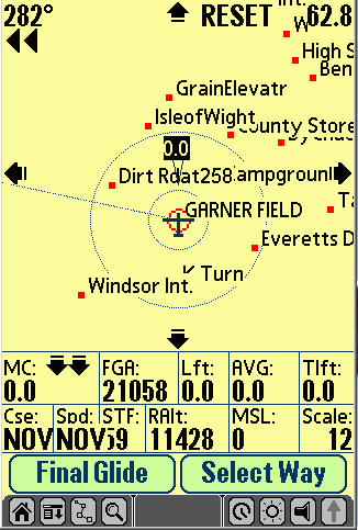
- Dynamic
Input
Area
Support
-
This
version
now
supports
devices
with
dynamic
input
areas(DIA),
also
known
as
Virtual
Silkscreen
Areas.
The
Garmin
iQue
is
such
a
device
as
well
as
the
Palm
Tungsten
3.
When
running
on
a
PalmOS
5.0
device
with
DIA
support,
the
program
lowers
the
silkscreen
area
when
viewing
the
Moving
Map.
The
moving
map
remains
the
same
size
but
the
additional
screen
area
is
used
to
contain
the
previous
bottom
labels
as
well
as
some
new
information.
First,
the
above/below
glideslope
arrows
are
moved
to
be
next
to
the
MC
label.
The
new
information
that
is
added
includes
the
current
lift/vario(Lft),
average
lift(AVG)
and
average
thermal
lift(Tlft)
values.
Also
there
are
two
large,
new
buttons
at
the
bottom
of
the
screen
labeled
"Final
Glide"
and
"Select
Way".
Because
the
Applications
and
Calculator
silkscreen
buttons
are
no
longer
available,
these
new
button
take
their
place.
When
the
Final
Glide
button
is
selected,
you
are
returned
to
the
Final
Glide
screen.
If
the
Select
Waypoint
button
is
selected,
the
waypoint
list
is
displayed
in
waypoint
selection
mode.
Finally,
if
a
waypoint
is
selected,
the
Final
Glide
Around
the
current
waypoint/all
task
points
is
displayed.
The
below
is
an
example
of
what
the
moving
map
would
look
like
running
on
the
Garmin
iQue:
Version
1.9.4
includes
the
following
new
features
and
fixes:
- Potential Program Crash for Reading Terrain Data - If
terrain data was in use and the current latitude EXACTLY matched the lower
bounds of the defined terrain data area, the program would crash. NOTE:
SPTerm had to be modified to fully correct
this problem.
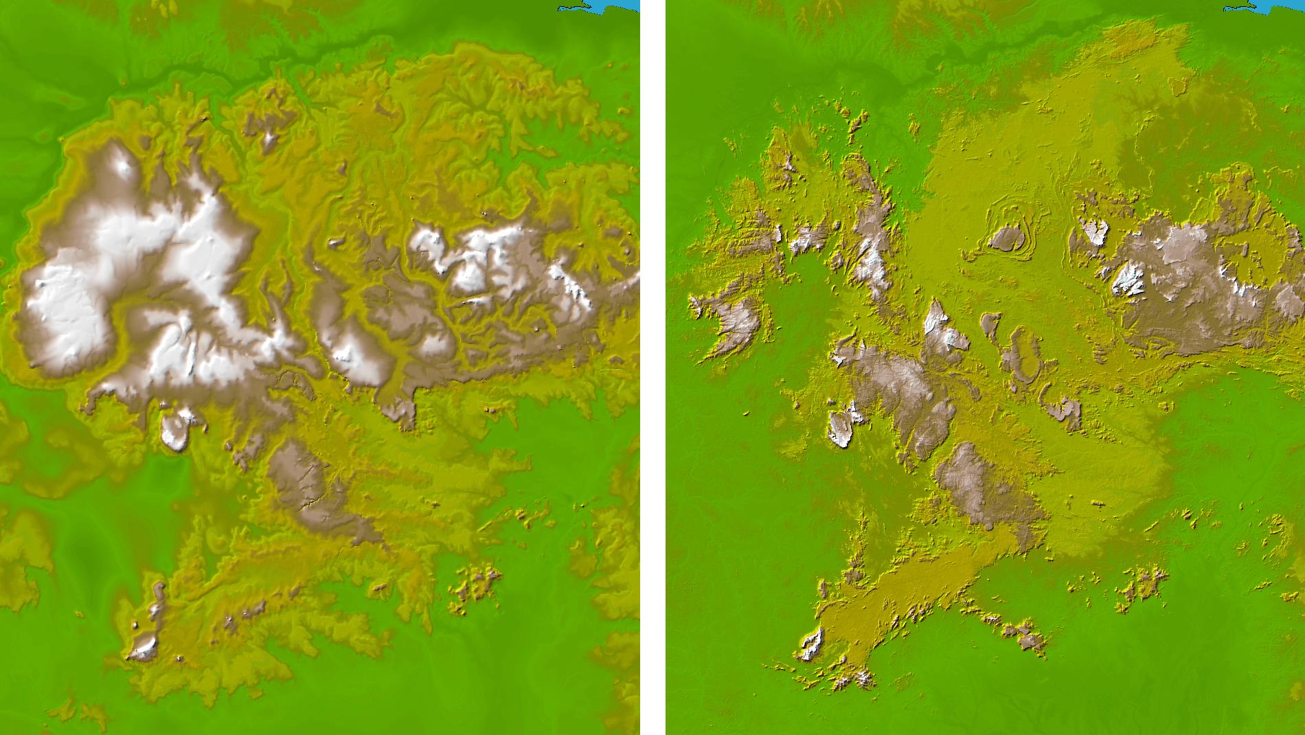
- New Version of SPTerm (1.3.4) - There is now a new version
on the webpage (1.3.4) which should be used instead of 1.3.3 for building
terrain data. While I have put in out-of-bounds checking into SoaringPilot
that will prevent the actual crash, if you have terrain data that was built
with SPTerm 1.3.3 you should rebuild it with 1.3.4 to ensure the terrain
data is accurate. Also while I was changing SPTerm, I made the program
create the "terrain" directory under the SPTerm install directory
when the program first runs.
- SRTM Data Uses Different File Extension - One item I
forgot to mention in the description below. When using the SRTM30
data the file that should be extracted from the downloaded .zip file does
NOT have a ".dem" file extension. Instead they used a ".hgt"
extension. The file size is still the same though (57,600) To allow
SPTerm to find and use these files, you need to rename the extracted file,
you need to remove the .hgt extension and replace it with a .dem extension.
Version
1.9.3
includes
the
following
new
features
and
fixes:
- Cambridge
302
Support
for
Task
Declaration
- When
you
activate
a task
and
you
have
"C302"
selected
as the
"Computer"
type,
it will
ask
whether
you
want
to declare
the
task
to the
logger
as well.
NOTE:
All
302
support
has
been
valdiated
again
version
2.63
of the
302
firmware.
- New
"Logger
Data"
Page
- If
configured
with
"C302"
selected
as the
"Computer"
type,
a new
button
is now
available
on the
"Logger
Info"
screen
labeled
"Logger
Data".
This
will
open
an additional
screen
that
is specific
to the
302
that
contains
information
required
to do
the
declaration/configuration
properly.
Right
now
the
302
is the
only
device
that
requires
this
additional
data.
However,
the
idea
is that
the
screen
displayed
would
match
the
configured
computer
device
allowing
support
for
future
devices
to be
added.
It may
be used
for
future
devices.
- Cambridge
302
Declarations
Can
Also
Include
Pilot
Info
and
Glider
Polar
Info
- Whether
it sends
Pilot
Info
and/or
Glider
Polar
Info
is user-selectable
on the
"Logger
Data"
page
mentioned
above.
If Pilot
Info
is selected
it passes
the
Pilot
Name
to the
302
making
it the
active
pilot.
If Glider
Info
is selected,
it passes
the
currently
selected
Glider's
Polar
info
to the
302.
- Cambridge
302
Waypoint
Transfer
Support
- If
configured
with
"C302"
selected
as the
"Computer"
type,
a new
"To
Logger"
checkbox
is displayed
on the
"Transfer"
screen
when
"Waypoints"
is selected.
If you
check
this
box
and
touch
the
"Transmit"
button,
all
waypoints
in the
attached
C302
will
first
be erased.
Then
all
of the
waypoints
in SoaringPilot
will
be transferred
to the
302.
You
can
use
this
to make
the
waypoints
in both
devices
match.
You
cannot
currently
recieve
waypoints
from
the
302
and
the
"Receive"
button
is disabled
if the
To Logger
options
is selected.
- Cambridge
302
Ballast,
MC Value
and
Bugs
Transfer
Validated
- Ensured
that
the
transfer
of this
information
is accurate
with
the
version
2.63
of the
302
Firmware.
Note
that
the
Bugs
value
is not
actually
used
by the
302
to degrade
the
polar
information.
- Polar
Performance
Info
on Polar
Edit
Screen
- As
part
of adding
support
for
passing
Glider
Info
to the
302,
I had
to calculate
the
Best
L/D
and
Best
L/D
Speed
and
Min
Sink
Speed
based
on the
three
point
polar
information.
Because
they
are
available
I now
display
them
on the
Polar
Edit
screen.
You
will
see
them
at the
bottom
of the
screen
showing
the
"calculated"
L/D
and
L/D
speed
as well
as Min
Sink.
I had
mixed
feelings
about
putting
that
info
there
as it
will
certainly
cause
some
questions
like,
"How
come
my L/D
value
is 37
instead
of 38?"
Even
given
that,
it still
seemed
like
useful
info
to display
to the
user
so I
decided
to leave
it.
Be aware
that
the
values
do not
get
automatically
recalculated
when
you
edit
the
various
fields
on the
polar
edit
page.
You
must
Save
the
new
values
and
re-edit
the
selected
polar
again
to see
the
new
performance
information.
- Terrain
Elevation
Data
Usage
- This
version
has
the
ability
to load
and
read
terrain
elevation
data
in order
to provide
a display
of the
current
terrain
elevation
as well
as an
"above
ground"
(AGL)
altitude
approximation
value.
This
terrain
data
will
come
from
a .pdb
file
that
you
will
have
to hotsync
into
your
PDA
(explained
below).
When
the
program
is running,
it uses
this
terrain
elevation
data
to determine
the
elevation
of the
ground
at your
current
location.
You
can
see
the
current
terrain
elevation
on the
Flight
Info
screen.
The
upper
part
has
a new
field
which
is always
updated
with
this
info.
If there
is no
terrain
data
loaded
or you
have
traveled
off
of the
loaded
data,
"N/A"
will
be displayed
in the
field.
In addition,
the
current
terrain
elevation
is saved
with
the
current
flight
information.
The
terrain
information
originates
from
GTOPO30-formatted
data
which
is readily
available
via
the
internet.
GTOPO30
is a
global
digital
elevation
model
(DEM)
with
a horizontal
grid
spacing
of about
30 arc
seconds
which
equates
to about
1 km.
I've
played
around
with
looking
at several
places
both
in the
UK and
in the
US comparing
the
GTOPO
elevation
with
the
reported
field
elevation
for
the
airfield.
With
a 1km
resolutioin,
it's
not
perfect
of course
but
it does
seem
to average
around
10-20
feet
of the
actual
value
for
the
airfield
I checked.
That's
not
too
bad
I think.
Actually
putting
in support
for
reading
this
information
was
not
too
difficult.
Also
because
of the
way
the
data
is laid
out
(every
grid
square
is .0833333333
of a
degree
on each
side)
it is
a simple/fast
calculation
to take
the
current
lat/long
and
go directly
to the
correct
row
and
column
in the
terrain
file
for
the
elevation
information.
While
a PalmIIIx
may
not
have
enough
RAM
to hold
the
data
it would
certainly
in no
way
make
the
unit
any
slower.
It was
very
nice
that
it worked
out
that
way.
What
took
longer
though
was
creating
a PC-based
conversion
program
to read
in the
.DEM
information
which
is HUGE
(40deg
x 50
deg
= ~57Meg),
allow
people
to specify
a smaller
area
(and
thus
smaller
size)
and
then
package
that
into
a .pdb
file
which
can
be easily
loaded
and
used
by SoaringPilot.
To support
this,
there
is a
new
version
of SPTerm
(1.3.3)
available
through
the
webpage
as well.
When
you
run
the
new
version
of SPTerm
you
will
find
there
is a
"Terrain"
menu
item
now
with
one
menu
item
which
says
"Generate".
Selecting
this
option
will
open
the
terrain
generation
window.
The
first
field
on the
screen
allows
your
to enter
the
filename
of the
terrain
.pdb
file
to be
outputted.
By default
it suggests
a filename
of "SoaringPilot_terrain_db.pdb"
and
I would
suggest
not
changing
that
name.
However
it really
doesn't
matter
what
you
call
it because
the
internal
filename
is the
only
one
that
matters
when
loading
it on
the
Palm
and
that
name
is hardcoded
to the
proper
value.
This
allows
you
to have
multiple
terrain
.pdb
files
with
different
names
to differentiate
the
area
they
correspond
to.
Then
you
just
have
to load
the
one
you
want
to use
before
you
head
out
to the
airfield.
Next,
you
must
enter
the
upper
and
lower
latitudes's
and
the
left
and
right
longitude's,
both
in decimal
degrees
with
S and
W being
negative.
Then
when
you
select
the
Generate
button,
it will
produce
the
.pdb
file
in the
"terrain"
directory.
However,
this
will
of course
give
you
an error
when
you
first
try
this
because
you
won't
have
the
required
.dem
data.
However,
it will
create
the
required
"terrain"
directory
under
the
SPTerm
install
directory.
To download
the
GTOPO30
data
and
make
things
work
properly,
you
will
need
to go
to:
http://edcdaac.usgs.gov/gtopo30/gtopo30.html
click
on the
sector(s)
you
want
to download
and
do so.
Each
sector
you
download
will
be a
.zip
file
of about
8 or
9 Meg.
Inside
these
zip
file
are
several
files
however
you
only
need
to extract
the
.dem
file
into
the
"terrain"
directory
under
the
SPTerm
directory.
This
is the
largest
file
in the
.zip
file
and
is about
57Meg.
If the
area
you
want
to define
for
terrain
information
covers
more
than
one
sectors/.dem
file,
you
will
need
to download
all
required
files
and
place
the
.dem
files
into
the
terrain
directory.
(NOTE:
If you
use
WinZip
please
see
the
note
on the
download
screen
for
each
sector.
If you
are
using
WinZip
to uncompress
the
.dem
file,
please
turn
off
(uncheck)
the
TAR
File
Smart
conversion
found
under
Options
/ Configuration
(or
under
Misc.
if using
Winzip
8.0)
The
terrain
generation
allows
using
a maximum
of 4
.dem
files.
Once
the
.dem
file(s)
is in
the
terrain
directory,
the
generator
will
work
properly
and
will
place
the
newly
created
.pdb
file
in the
terrain
directory
as well.
You
simply
have
to hotsync
this
.pdb
file
onto
your
Palm
PDA.
Finally,
as a
result
of NASA's
SRTM
(Shuttle
Radar
Topography
Mission)
last
year,
a new
topographical
dataset
is also
available
in the
same
GTOPO30
format.
It is
called
SRTM30.
SRTM
data
was
used
to update
the
older
USGS
GTOPO30
global
DEM,
by averaging
the
data
to 30
arc-sec
resolution
and
replacing
GTOPO30
heixels
between
the
latitudes
of 60°
North
and
56°
South.
The
resulting
data
can
be directly
downloaded
and
is now
the
best
available
global
elevation
dataset.
Below
is an
example
so you
can
see
the
improvements.
The
left
image
is the
old
data.
The
right
is after
being
updated
with
SRTM
data.
As you
can
see,
the
right
is much
more
accurate.
This
is because
SRTM30
replaces
the
wild
guesswork
of previous
data
with
actual
measured
values.

The
new
data
uses
the
same
names
as the
previous
GTOPO30
data
so once
you
find
the
filename
you
want
to download
from
the
GTOPO30
site,
go to
the
following
URL
and
download
the
same
file:
http://edcsgs9.cr.usgs.gov/pub/data/srtm/SRTM30/.
- Updated
Altitude
vs Time
Graph
- Using
the
stored
terrain
information,
the
Altitude
vs.
Time
graph
has
been
enhanced
to show
the
terrain
elevation
as well.
Let's
you
see
just
how
close
you
were
to that
ridge
top.
:-)
- User-Selectable
Altitude
Display
Mode
-
The
options
are
MSL,
AGL
and
QNH.
You
can
select
the
mode
from
the
"Final
Glide
Setup"
page.
In addition,
you
can
change
the
mode
on-the-fly
by selecting
the
Altitude
Label
on the
Final
Glide
screen
or selecting
the
Altitude
area
at the
bottom
of the
Moving
Map.
The
following
are
specifics
about
each
mode:
- MSL
-
This
can
have
three
different
sources
depending
on
how
you
have
the
program
configured:
- GPS
Altitude
-
If
"GPSAlt"
is
selected
on
the
NMEA/Port
screen
for
Altitude
type,
this
will
display
the
GPS
Altitude
coming
from
the
attached
GPS.
- Pressure
Altitude
-
If
a
pressure
altitude
type
is
selected
on
the
NMEA/Port
screen
AND
"Press.
Alt
for
Display/Lift"
is
selected,
the
field
will
contain
the
pressure
altitude
coming
from
the
attached
device.
- C302
True
Altitude
-
If
C302
is
selected
for
computer
type,
the
true
altitude
coming
from
the
302
will
be
used.
- QNH
-
This
mode
takes
the
MSL
value
that
would
be
displayed
in
MSL
mode
and
adjusts
it
for
the
Field
Elevation
value
entered
on
the
NMEA/Port
screen.
- AGL
-
This
mode
takes
the
terrain
information
described
above
and
applies
it
to
the
MSL
value
coming
from
the
GPS
to
give
an
approximate
"Above
Ground
Level"
value.
If
no
terrain
data
is
loaded
OR
if
the
current
position
is
not
within
the
bounds
of
the
defined
terrain
data,
"N/A"
displayed
for
the
altitude
value.
This
is
to
signify
that
you
no
longer
have
an
AGL
approximation
and
should
shift
to
one
of
the
other
altitude
modes.
- Key
Sound
On/Off
Setting
- Reformatted
the
Units
Setup
page
to acomodate
the
check
box
to turn
off
the
button
sound.
Allowed
me to
display
"Time
Zone"
instead
of "TZ"
as well.
- FAI
Task
Start/Finish
Options
- There
are
now
start
and
finish
task
options
which
allow
the
use
of FAI
sectors.
These
use
a 90
degree
sector
for
the
start
and
finish
sectors.
- Exit
Start
Cylinder
to Start
Task
- If
configured
for
a cylinder
start,
the
task
does
not
actually
start
until
you
enter
AND
then
leave
the
cylinder.
- Task
Start
and
Finish
Cylinder
Radius
Values
Subtracted
From
Task
Length
- If
you
have
selected
Cylinder
as the
task
start
or finish
type,
the
actual
radius
of these
cylinders
is now
subtracted
from
the
overall
task
distance
.
This
makes
the
task
distance
value
more
accurate
and
makes
the
various
task
time
calculations
more
accurate
as well.
-
Thermal
Waypoint
Type
-
In preparation
for
the
"optional"
auto-storing/auto-plotting
of thermals,
you
can
now
select
a waypoint
type
of "Thrml"
on the
waypoint
edit
screen.
If you
do this,
a new
symbol
is used
to plot
that
waypoint
on the
moving
map.
It is
a circle
with
a "T"
in it.
- New
Map
Symbrols
- Related
to that,
the
moving
map
can
now
display
waypoints
with
three
different
symbols.
Turnpoints
that
are
"landable"
are
displayed
with
a circle
with
a dot
in the
middle.
Turnpoints
that
are
NOT
landable
are
displayed
with
just
a dot.
Finally,
as described
above,
if the
"Thrmal"
attribute
is set,
it displays
as a
Circle
with
a "T"
in it.
- Map
Waypoint
Coloring
- Due
to readability
issues
on color
screens,
the
waypoint
labels
are
no longer
displayed
with
either
the
green
or red
colors.
The
actual
waypoint
symbols
IS displayed
with
the
correct
color.
Also,
the
text
label
IS still
displayed
as bold/all
capitals
letters
for
in range
or normal
letters
if out-or-range.
-
Moving
Map
Altitude
Value
Corruption
- Fixed
the
problem
with
the
altitude
values
becoming
incorrect/out-of-range
on the
moving
map
when
thermalling
(positive
sink
values)
or in
ridge/wave
lift.
- Fast
&
Slow
Log
Values
- The
Logger
Config
screen
now
has
Fast
and
Slow
Log
values.
Slow
is used
normally
but
it will
switch
to Fast
when
you
get
close
to a
turnpoint
of a
defined
task.
- Lift
Calculation
Bug
- Fixed
a pretty
major
bug
in the
way
lift
was
being
calculated.
Basically
I was
calculating
lift
evertime
the
altitude
value
was
updated.
This
sounded
fine
and
worked
pretty
well
in most
cases.
However
a reported
problem
with
the
Volkslogger
lead
me to
find
this
issue.
The
problem
is that
it was
possible
that
the
altitude
could
change
(and
thus
the
lift
recalculated)
even
though
there
had
been
no change
in time
value
from
the
GPS.
Thus
the
actual
lift
calculation
could
be off
by as
much
as half
of what
it should
be.
The
volkslogger
was
probably
the
worst
case.
When
I finally
reduced
down
the
NMEA
data
from
it getting
rid
of the
extraneous
sentences
and
leaving
the
GGA,
RMC
and
PGCS,
I found
that
it ouputs
the
proprietary
pressure
altitude
sentence
along
with
BOTH
the
GGA
and
RMC
sentences.
IOW:
$GPGGA
$GPGCS
$GPRMC
$GPGCS
Since
I take
time
from
EITHER
the
GGA
(NMEA
version
2.0
or above)
OR RMC
(version
1.5
or below),
it was
then
recalculating
lift
for
every
PGCS
sentence
however
the
time
was
only
changing
for
every
other
lift
calculation.
Thus
while
the
altitude
was
changing,
every
other
lift
calc
would
be zero
(lift
change
but
no time
change)
while
the
next
time
it would
have
an actual
lift/sink
value.
However,
every
time
the
lift
calc
function
is called,
it saves
off
the
last
altitude
value
to be
used
the
next
time
through
to determine
a difference.
So even
though
the
call
with
no time
change
would
result
in a
zero
lift/sink
value,
it was
still
saving
that
altitude
for
the
next
time
through.
Thus
even
though
there
was
a time
difference
that
spanned
both
altitude
sentences,
the
calculation
was
only
based
on half
of the
altitude
difference.
This
was
why
the
Volkslogger
lift/sink
value
was
about
half
of what
it should
have
been
when
set
to use
pressure
altitude.
Now,
I simply
make
the
lift/sink
calculation
ONLY
when
the
time
changes.
It should
actually
make
the
value
a bit
more
stable
as well
in all
cases.
- Bluetooth
GPS
Support
- Added
support
for
reading
NMEA
data
from
a Bluetooth
GPS.
If the
Palm
device
is Bluetooth
capable,
you
will
now
see
a "BT"
button
in the
top
part
of the
NMEA/Port
screen
next
to the
current
"Serial"
option.
If you
don't
have
Bluetooth,
just
the
"Serial"
option
will
be shown
and
selected.
I have
tested
this
with
my Tungsten
T and
a BT
USB
adaptor
on my
laptop.
It works
REALLY
well.
This
is certainly
an option
to consider.
The
current
crop
of BT
GPS'
will
run
for
seveal
hours
on their
internal
batteries.
The
ENTAC
unit
has
a lithium
ion
battery
with
a 6+
hour
battery
life.
So you
could
just
put
the
GPS
wherever
is convenient
and
turn
it on.
Then
turn
on your
Palm
PDA
with
SP,
connect
to it
from
the
BT picklist
that
is displayed
and
you're
good
to go.
No cables
necessary.
Of course
the
BT GPS
can
also
be powered
from
the
sailplane
battery
if you
would
like
as well.
It's
certainly
something
to think
about.
- Turn
Direction
Arrows
on Moving
Map
- On
the
moving
map,
when
a waypoint
is selected,
you
can
now
see
turn
direction
arrows
just
below
the
waypoint
direction
in the
upper
left
corner
of the
screen.
There
can
be one
or two
arrows,
or none
at all,
depending
on how
far
off
course
you
are.
Here
are
the
rules
on when
they
are
displayed:
- Nothing
-
If
you
are
within
+/-
5
degrees
of
the
course,
no
arrows
will
be
displayed
- One
Arrows
-
If
you
are
between
5
and
10
degrees
off
the
require
course,
you
will
see
one
arrow
in
the
correct
direction.
- Two
Arrows
-
If
you
are
greater
than
10
degrees
off
the
required
course,
you
will
see
two
arrows.
- Multiple
Above/Below
Glideslope
Arrows
- First,
the
above/below
arrows
are
displayed
at all
times
when
a waypoint
is selected.
Previously
it was
only
displayed
when
in D.ALT
mode.
Second,
there
can
now
be one
or two
arrows
depending
on how
much
above/below
you
are.
The
rules
for
when
they
are
displayed
are:
-
Two
Up
Arrows
-
Above
2
Times
the
Safety
Altitude
-
One
Up
Arrow
-
Between
Safety
Altitude
and
2
Times
the
Safety
Altitude
-
One
Down
Arrow
-
Between
Zero
A.Alt
(Arrival
Altitude)
and
the
Safety
Altitude
(marginal
final
glide)
- Two
Down
Arrows
-
Negative
A.Alt
- Dual
MC/Sink
Range
On Final
Glide
Page
- For
those
pilots
that
are
lucky
enough
to fly
in regions
of the
world
with
consistent
lift
over
5 knots
(or
equivalent),
there
are
now
two
ranges
for
the
six
MC/Sink
values
on the
Final
Glide
page.
The
Low
range
goes
from
0 to
5knots/ms
or 0
to 500
fpm.
The
High
range
goes
from
0 to
10 knots/ms
or 0
to 1000fpm.
The
altitude
and
speed
values
will
match
the
current
range.
The
current
display
range
is toggled
by touching
the
MC(Speed
Opt
Mode)/Sink(Distance
Opt
Mode)
column
heading/label.
The
current
range
value
is retained
if you
exit
the
program
and
start
it again.
- Reading
SeeYou
Waypoints
- You
can
now
read
in waypoints
in the
SeeYou
.cup
format.
I have
not
yet
implemented
reading
the
tasks
from
the
.cup
format
but
will
do so
in the
future.
Andrej
is supposed
to be
updating
his
.cup
format
document
to include
information
on the
additional
AREA
turnpoint
information.
That
will
be included
as well.
Version
1.9.2
includes
the following
new features
and fixes:
- MC Value On Moving Map Not Displayed in Selected Units
- The moving map will now show the MC value in the correct units.
- Final Glide MC Values Incorrect for m/s and fpm Lift Units
- While fixing item #1 I found that no matter what lift units were selected,
the final glide screen speed and altitude values were still being displayed
using knots. This has now been fixed.
- Colibri/LX Wind Parsing Error - Was parsing the incorrect
field numbers for the wind speed and direction being outputted in the LXWP0
sentence.
- No Data Timeout Value Not Saved Properly - If SP was configured
with AutoOff disabled and changes made to the No Data Time out field would
not be saved. The value will not be saved regardless of the AutOff option.
- Flight Info Screen Now First On "Find" Button Chain
- This was done to make sure there is no confusion on over which silkscreen
button was selected when on the Final Glide page. In the next version
I will make it a user-selectable option of whether the Flight Info screen
is first followed by the waypoint list (in view mode) or vice versa.
- Waypoint List Title Bar Now Shows the Mode - In addition
to showing which altitude mode is currently in use, it will also show which
mode the window is being displayed in. If it is in view mode (accessed
through the menu or the Find button chain) the window title bar will say "Waypoint
List-" and the altitude mode. If it is in waypoint select
mode it will now say "SELECT Waypoint-" and the
altitude mode.
Version
1.9.1
includes
the following
new features
and fixes:
- Final
Glide Around All
Task Points
- When a task
is active, the
FGA field on the
Final Glide page
will now display
altitude information
(depending on
your selected
altitude mode)
from your current
position around
all remaining
turnpoints. Paul
Gleeson used an
earlier beta version
which included
this, in a 3 day
competition in
the UK.
He was able to
win the Novice
class with a handicapped
speed of 116kph
in a DG100.
Of the FGA info
he said, "It
was very useful
to know that soon
after my first
turnpoint, I had
enough height
to fly the rest
of the task. I'm
sure this contributed
to my speed as
my final glide
started well before
I made the last
turnpoint."
Hopefully others
will find it useful
as well.
- MUCH
Faster STF Calculations
- Hamish Baker
(Paraglider Pilot
in the UK) found
a problem with
the Speed to Fly
calculations when
using Parasail
polar info.
He diagnosed and
found the problem
and fixed it.
In the
process he also
optimized the
STF calculation
for both the Speed
and Distance Optimization
modes making them
noticeably faster
than before.
The difference
is quite remarkable
and Hamish should
be commended for
this wonderful
contribution.
This one
item alone will
help lower powered
Palm users more
than anything
else.
- Temporary
Waypoint Selection
When Task is Active-
This is an enhancement
which has been
requested by several
users. If
a task is active
and you select
the "Calc"
silkscreen button
from the Final
Glide or Moving
Map screens, you
will now be presented
with a window
which, among other
things, allows
you to essentially
place the current
task "On
Hold" and
select a temporary
waypoint.
After selecting
the "TEMP"
option, you will
then be presented
the Waypoint list
in "Selection"
mode. If
you select a waypoint
and then touch
the "Calc"
button, you will
be returned to
the previous screen
as always.
However the selected
waypoint will
now be the temporary
waypoint.
This temporary
waypoint will
then be used for
all calculations.
If you
then want to continue
on the task, you
can easily resume
the task where
you left off by
selecting the
"Calc"
button again from
the above screens
and selecting
the RESUME option.
If you
choose the TEMP
option but then
decide you don't
want to have a
temporary waypoint,
simply don't select
a waypoint from
the waypoint list
and the current
task will remain
active.
- Map
Scale Values
- This item actually
consists of two
changes:
- There are
now more Map
Scale values
when using
the PageUp
and PageDown
buttons on
the moving
map.
The options
are now:
0.2, 0.5,
1, 2, 3, 5,
8, 10, 12,
15, 20, 30,
50, 80, 100,
120, 150,
200, 250,
300
- Also, the
above values
are now displayed
and used in
the selected
distance units.
Previously,
it was always
using nautical
miles but
simply converted
for display
in the selected
units.
Now, if the
units are
set to kilometers
and the mapscale
says "10",
it means 10km
and the map
is drawn with
a width of
10km.
- Task
Info Additions
- With Paul Gleeson's
help, the task
information displayed
on the Flight/Task
Info screen has
now been significantly
enhanced.
All of these values
are automatically
updated as the
task is progressing
with final values
saved for later
review as well.
The new fields
include:
- Task
Total Distance
- This is
the same value
as displayed
in the Task
Editor for
the total
task distance.
- Task
Current/Accomplished
Distance
- This value
is updated
as you fly
the assigned
task.
After the
task has been
completed,
if this flight
is then selected
for review
later, the
distance of
the task that
was accomplished
(all or partial)
will be displayed
as well.
- Elapsed
Time Since
Task Was Started
- This was
in previous
version but
the label
is now changed
to "Elap"
- Current
Task Speed
- This is
the current,
effective
speed for
the task.
This value
is updated
while the
task is active
based on the
current elapsed
time and
the distance
accomplished.
The final
value is also
saved with
the flight
when the task
is finished
(completed
or partial).
Also, this
information
is displayed
in the current
user-selected
speed units
in the left
field and
then always
displayed
in kph in
the right
field.
- Estimated
Arrival/Task
Completion
Time
- This time
is updated
while the
task is active
based on the
current calculated
task speed
and the distance
remaining
in the assigned
task.
The final
value is saved
with the flight
when the task
is finished
(completed
or partial).
- Percent
Thermal Graph
Additions on Flight
Info Screen
- When a flight
is not actively
being logged,
there is now a
second button
at the bottom
of the Flight/Task
Info screen labeled
"%Th/TIME".
Depending
on whether there
was a task assigned
to the selected
flight, this button
will display one
of two graphs:
- %Thermal
vs. Time Graph
- This graph
will be displayed
if no task
was assigned
for the selected
flight.
It will display
a bar graph
with 6 different
bars each
representing
1/6th of the
total flight
time.
These six
bars represent
the percentage
of time you
spent thermalling
during each
of those 6
time periods.
- %Thermal
vs. Task Leg
Graph -
This graph
is similar
to the above
except that
it presents
a bar for
each task
leg.
Thus it represents
the percentage
of the time
while working
on a given
task leg that
you spent
thermalling.
- Thermal/Cruise
Sensing with EW,
Colibri or 302
- Fixed a parsing
issue causing
problems with
the thermal/cruise
sensing when configured
for EW or Colibri
while connected
to a computer
running
Sailors of the
Sky(SotS,
www.sailorsofthesky.com)
soaring simulator
with it configured
for NMEA output.
Actually,
it wasn't specific
to SotS. You would
have seen it in
the real world
as well if flying
with either a
Colibri, EW or
Cambridge 302.
Both were
causing havoc
with the thermal/cruise
sensing code.
It's all
taken care of
now though.
SotS
was a BIG
help
in getting this
working correctly
though as well
as troubleshooting
and testing other
items as well.
It wasn't
parsing the LXWP
sentence (item
above) correctly
so the wind info
was not even being
used from that
sentence.
If you have not
yet tried Sailors
of the Sky, I
would HIGHLY
encourage
you to give it
a try. It
is an OUTSTANDING
gliding simulator
and the only one
which supports
multiplayer operation.
In addition, using
the optional NMEA
output it is THE
best way to get
used to using
SoaringPilot with
essentially real-world
conditions and
operations BEFORE
you actually get
in a real glider
and fly.
You just connect
your Palm PDA
to your computer
and turn on the
NMEA output in
the SotS configuration.
When the simulation
starts it will
begin outputting
NMEA data for
the location of
the glider you
are flying.
If you have waypoints
loaded into SoaringPilot
for the scenery
you are flying
with in SotS,
everything will
be displayed as
if you were actually
flying there.
If you want to
just learn how
to use SoaringPilot
with Sailors of
the Sky, SotS
has a full automatic
mode where the
computer essentially
"flies"
the assigned task
for you stopping
to thermal along
the way as necessary.
That leaves you
free to just try
the different
functions of SoaringPilot
at your leisure.
- Waypoint
List Always Calculates
Values Before
Display
- Previously the
values on the
waypoint list
were updated in
the background
so to be sure
the information
in the list was
current you would
need to wait a
few seconds once
the list was displayed
for the values
to be updated.
Now, with the
updated/faster
STF calculations
(Thank-you Hamish!!),
the values can
be calculated
BEFORE the list
is displayed without
the user having
to wait a long
time for the list
to display.
So when the list
is displayed now,
the values are
correct.
They will continue
to be updated
automatically
as the glider
moves as well.
In addition, the
values are also
updated before
the list is displayed
when changing
the current page
of the waypoint
list with the
PageUp and PageDown
buttons.
- System
ROM ID and Logger
UID Displayed
and Outputted
in IGC Flight
Output (Robert
Hawley) - This
item was done
to support the
current Canadian
competition rules
and allow SoaringPilot
to be used for
flight verification
for competitions
in Canada.
- Logger
"No Data"
Timeout Value
Now User Configurable(Simon)
- Previously,
this value was
hard-coded to
30 seconds.
Therefore, if
a flight is being
logged and no
data is received
from the attached
GPS within 30
seconds, the flight
would be stopped.
If the connection
was restored,
a new flight entry
would be added.
While this would
not normally be
a problem when
in a glider, if
you wanted to
use SoaringPilot
for other uses
(ex. logging data
during hiking,
etc.) there could
be periods where
GPS coverage was
not available
causing multiple
flight log entries.
I have now exposed
this setting so
it can be set
to a higher value
if you wish.
I would
HIGHLY
encourage you
to leave the value
at the default
of 30 seconds
for gliding usage.
However, the choice
is now yours.
- Auto
Thermal Zoom Has
Hi and Low Settings
(Miha Razinger)
- Miha is a paraglider
pilot and he suggested
that the previous
auto thermal zoom
radius or .5NM
was too large
for paragliders.
An option has
now been added
to the Map Setup
page to allow
you to select
a Low
or Hi
map zoom factor
when thermalling.
The low value
represents the
current .5NM values
while the hi option
will zoom down
to .3NM instead.
The other option
"O"
allows you to
turn off auto
thermal zoom completely.
- Auto
Task Zoom Now
Available and
Configurable
(Paul Gleeson)
- Again, with
Paul's wonderful
testing support
and advice, auto
task turnpoint/taskpoint
zooming has now
been added.
When enabled on
the Map Setup
page and a task
is active, as
you approach a
given point of
the assigned task,
the map will automatically
zoom down through
a set of "stairsteps"
progressively
lowering the map
radius yet keeping
the taskpoint
on the screen.
This auto-zooming
is driven by the
size of the current
taskpoint.
So a large AREA
turnpoint of several
miles will be
handled differently
from a smaller
FAI turnpoint
sector, for instance.
Once the taskpoint
is accomplished,
the map will automatically
zoom back out
to the original
map scale value
that was in use
when the auto-zooming
began. There
is one caveat
to this auto-zooming.
For a given task
point, if the
map has already
been automatically
zoomed once and
you then manually
change the map
scale with the
PageUp/PageDown
keys, the manually
selected map scale
will be used without
further zooming.
This manual value
will remain in
effect until the
taskpoint is accomplished.
After that the
map will auto-zoom
back out as described
above and the
auto-zooming for
the next taskpoint
will begin when
appropriate.
- Two
Range Rings On
Moving Map -
Two Range Rings,
centered on the
glider symbol,
can now be enabled
and displayed
on the Moving
Map. They
are configured
from the Map Setup
page allowing
you to set the
radius of each
ring as you see
fit. If
you set the value
of either one
or both rings
to "0",
the ring will
not be displayed
on the map.
- Task
List Will Now
Wrap Around Like
the Waypoint List
- When
using the PageUp/PageDown
keys to move through
the saved tasks,
if the PageUp
key is pressed
from the Active
Task slot, the
last stored task
will be displayed.
Also, if the last
stored task is
being displayed
and the PageDown
key is pressed,
the Active Task(first)
will be displayed.
- Task
List Total Distance
Round Down
- When the task
distance is displayed,
the value is rounded
down to the displayed
precision.
That way if the
displayed distance
is 300km you can
be assured it
is REALLY 300km
and not 299.6km,
for example, which
might invalidate
any flight distance
award claims.
- Added
Support for Imperial
Gallons
(Myles Lemon)
- Myles requested
that Imperial
Gallons be added
for ballast units
since some glider
manuals use this
for units.
- Modified
the Find Button
Screen Order
- It now is:
Final
Glide-Waypoint
List-Flt Info-Task
Edit-Wind Info-Final
Glide Setup-Moving
Map
Doing this allows
for easily switching
between the Waypoint
List and Final
Glide Page with
the Find
button AND
between Final
Glide Page and
Moving Map with
the Home
button. Given
the confusion
with getting to
the waypoint list
with the Calc
button (in select
mode), this seemed
like a good thing
to do.
- Current
MC Value Determination
While Thermalling
- The Current
MC Value in Distance
Optimization when
thermalling is
now determined
based on the current
MC setting and
the averager value
when thermalling
began. Previously
it was using the
averager value
while thermalling.
The positive averager
values would cause
the altitude fields
to show incorrect
values.
In addition, the
saved averager
value is also
used to "kick
start" the
averager values
when the program
shifts from thermalling
back into cruise
mode.
- GPS
Disconnect Audible
Alert
- An audible alert
will now be sounded
if there is an
active flight
AND the software
does not get data
from the GPS.
Depending on the
speed of your
PDA, it may take
from 3 to 10 seconds
for the software
to make the "no
data" determination.
Once the alert
begins sounding,
it will continue
to sound until
the connection
is restored or
the "No Data"
timeout value
(described above)
is reached and
the flight logging
is terminated.
- Deactivating
The Active Task
No Longer Clears
the Task Info-
Previously, when
you deactivated
the active task
and selected a
GOTO waypoint,
the taskpoints
for that task
would be cleared
out of the "Active
Task" slot
in the Task Editor.
It no longer
does that but
just deactivates
the task.
- In Range
Waypoints Displayed
in All Caps on
Moving Map -
If a waypoint
is in gliding
range, in addition
to being displayed
in bold and, if
on a color screen,
in green letters,
it will also now
be displayed with
all capital letters.
It does not actually
change the waypoint
label to all capital
letters but just
displays it that
way. If
someone makes
their waypoint
labels normally
with all CAPS,
they could get
confused I guess
but there isn't
much I can do
about that plus
the other indications
are still valid.
- "BL"
No Longer Overlaps
GPS Status Info
- On the Final
Glide screen,
the "BL"
(Backlight On)
and "NO GPS"/"NOSATS"
status indicators
in the upper right
hand corner of
the screen no
longer overlap.
Note that I had
to change "NO
SATS" to
just "NOSATS"
to make things
fit properly.
I'm sure this
will not be a
difficult adjustment
for everyone.
:-)
- Fixed
Parsing of Wind
Info from LX/Colibri
- The
parsing of the
LXWP0 sentence
from LX Navigation
instruments was
not parsing the
wind information
correctly.
This has now been
fixed.
- Fixed
a Problem Where
Saving Your Configuration
to DOC, Memo or
Flash with
the current mapscale
set to something
less than 1.0,
it was only saving
the value of "0".
So when you read
it back in, the
mapscale would
be set to zero
and could not
be anything higher.
I fixed the output
and put in protection
for the value
getting read in
as zero. If it
is zero, it will
set it to 2nm.
- Fixed
a Problem With
the Wrap Around
of the Waypoint
List where
it would display
an empty page
and say "No
Waypoints"
if there were
enough waypoints
to fill all the
pages.
- Fixed
a Case Where a
Blank Screen would
be displayed when
declaring a task
to an EW logger.
- Fixed
a Bug with the
Task Editor
where removing
an entry from
the Active Task
(even if it wasn't
active at the
time) would reset
any waypoint that
was currently
in use.
Even if no waypoint
was in use, it
would cause unknown
values to be displayed
for the bearing
and range on the
Moving Map.
- Fixed
a problem with
the Waypoint List
when using a high
resolution screen,
the list would
be displayed in
a reduced size
on the screen.
Version
1.9.0 includes the
following new features
and fixes:
- EW Logger Task
Declaration Support
- When a task is Activated
or Re-Activated AND
"EW" is selected
as the Computer type on
the NMEA Port screen, the
user will be asked if the
current task should also
be declared to the attached
EW datalogger as well.
There are other additional
dialogs which can be displayed
during this declaration:
- "Transferring..."
dialog will be displayed
during the transfer
- "Declaration
to EW Logger Succeeded!"
dialog will be displayed
if the transfer is successful
- "Declaration
to EW Logger Failed"
dialog will be displayed
if any problems with
the transfer are encountered
- "Too Many Turnpoints
in Task" dialog
is displayed if the
current task has more
than 6 turnpoints excluding
the Takeoff and Landing
turnpoints if defined
in SoaringPilot.
The EW only supports
tasks with a max of
6 turnpoints including
the Start and Finish
turnpoints, and does
not support the concept
of Takeoff and Landing
turnpoints.
- "Logger is active!
Changing declaration
could invalidate flight
claim." dialog
will be displayed if
you attempt to declare
to the EW when the SP
logger is active indicating
that you are flying.
- "Clear Logger
Task Declaration?"
dialog is displayed
if the ACTV button is
selected from "Active
Task" with no turnpoints
in it. This is
a convenient way to
clear the current task
declaration in the EW
Logger.
- "Clear Declaration
Failed" dialog
will be displayed if
item #6 fails for any
reason.
- Colibri Wind Can
Now Be Used - If
attached to a Colibri datalogger
and "Colibri"
is selected as the Computer
Type on the NMEA/Port screen,
the wind data from the Colibri/LX20
will be parsed and used
instead of the internal
wind calculations done but
SP. If you do not
wish to use the Colibri
wind calculations, just
unselect it as the computer
type. Wind speed and
direction are the only items
being read in this mode.
Pressure altitude will still
be read if "Colibri"
is selected as the Pressure
Altitude source in either
case.
- Waypoint L/D Value
Removed- This value
on the Final Glide settings
screen was no longer being
used by the program.
So it has now been removed.
- On the Final Glide settings
screen, the ToDo and Notepad
buttons now increment/decrement
the Safety Altitude value
by 10 units depending on
the units selected for altitude.
- The "Pilot/Glider"
screen has now been renamed
to "IGC Info"
on the menu.
In addition, to support
the EW task declaration,
two new fields have been
added to hold the user's
GPS Model
and GPS Serial Number.
- The GPS Model and GPS
Serial Number are now outputted
in the new IGC HFGPS line.
The field they define are:
HFGPS:MANUFACTURER,MODEL,#CHANNELS,MAXALTITUDE
However, I ended up outputting
it as:
HFGPS:GPSMODEL,GPSSERIAL,"12"(hardcoded),(empty)
The 12 is hardcoded and
the altitude is empty. The
other two fields aren't
exactly what they define
but their just text fields
anyway. Besides, SP can't
be an approved logger so
what do I care? ;-)
- Fixed a bug where the
label for the the current
turnpoint of a task would
first be drawn with bold
letters then over-drawn
with regular letters.
It should have just been
drawn with regular letters
indicating that it is out
of range. This has
now been corrected.
- The "Cse/Spd"
& "Bear/Rng"
data and labels on the Final
Glide screen have now been
switched. This puts
the Cse/Spd info in the
same location on the screen
for both the final glide
and moving map screens.
- It also has been brought
to my attention that when
I described the Task enhancements
below, I forgot to include
a description of the "T"
and "L" options
in the lower right hand
corner of the screen.
So the following is an attempt
to take care of that:
The "T" and "L"
stand for Takeoff and Landing,
respectively. If they
are NOT selected, the first
and last turnpoints in the
list are then the Start
and Finish turnpoints and
treated accordingly. If
you have "T" and/or
"L" selected,
then the first and/or last
turnpoints would be treated
as either a Takeoff and/or
Landing point with the second
and/or next to last turnpoints
becoming the Start and Finish.
Version 1.8.9 includes
the following new features
and fixes:
- Fix for program crash if trying
to read in nonexistent file from a
Flash Card (Janos Bauer)
- Fix for problem with the Wind Info
screen where, if wind calculation
is switched off and velocity unit
is kph or mph, every time one comes
to the wind info dialog, the value
of wind direction gets manipulated(conversion
factor for knots to kph)(Manfred
Kargl)
- Fix for how the field elevation
value gets applied. The field elevation
value was being added to altitude
values rather than subtracted. It
now is used properly. (Janos
Bauer)
- The Field Elevation value can now
be entered for normal GPS altitude
as well as the pressure altitude values.
This allows you to change GPS altitude
to an AGL approximation value. The
only time the field elevation value
isn't used is when the Cambridge 302
is selected as the configured flight
computer type. In that case,
the true altitude value is read directly
from the 302.
Version 1.8.8 includes the
following new features and fixes:
- IGC "G" Record Addition
and Validation - Even thought SoaringPilot's
logger is not an "IGC Approved" logger,
I have added IGC "G" security records
to the flight output. In addition, a DOS
Validation program (VALI-XSP.exe) is now available
on the Downloads page of the SoaringPilot webpage.
This program can be used to validate and flight
info output by version 1.8.8 and above.
While the IGC and the US Racing rules do not
allow SoaringPilot's logger output to be used
for flight verification, I have been approached
by representatives from Canada, Slovenia and
Brazil who believe that with the addition of
the "G" lines and corresponding validation
program, SoaringPilot's logger output can be
used in those countries for competitions.
I applaud those individuals for having a realistic
point of view on this topic and hope the rest
of the soaring community will come to it's senses
as well.
- HI-RES 320x320 Pixel Support on PalmOS
5.0 Units - On PalmOS 5.0 units with
HI-RES screens, SoaringPilot will display the
map in 320x320 mode providing a mode detailed
map presentation.
- Above/Below Glide Slope Arrow on Map
- When in D.ALT altitude mode and a waypoint
is selected, an UP or DOWN arrow will be displayed
in the upper left corner of the screen below
the Final Glide altitude and speed info.
If on glide slope, nothing will be displayed.
- Current McCready(MC) Value on the
Moving Map - The current MC value is
now displayed on the Moving Map. In addition,
when in manual MC mode, the value can be changed
from the moving map using the same buttons as
the Final Glide screen (Right two hardware buttons
- Todo and Notepad).
- Button for Add New/Manual Waypoint
from Moving Map Changed - To
support the above MC value and configuration,
the current button (Notepad) had to be changed.
It is now the far left hardware button (Calendar).
- Current Altitude Mode Displayed on
Moving Map - The current altitude mode
(DALT, RALT, AALT) is now displayed on the moving
map as the label for the altitude.
- Final Glide Altitude Mode Selectable
from Moving Map - The current altitude
mode can now be selected from the moving map.
This is done by touching the area of the screen
where the final glide altitude and label are
being displayed. When touched, the area
with be displayed in inverse mode then will
return to normal when the mode is changed.
As described above, the label for the FG altitude
will also change.
- All Final Glide Info on the Moving
Map Moved to Bottom of Screen - When
a waypoint is selected, the recommended final
glide altitude, speed, current MC setting and
Above/Below GS Arrow will now be displayed at
the bottom of the screen instead of the in the
upper left hand corner. In addition, the
values have been grouped with the similar types
of values currently on the bottom of the screen.
Altitude values are together, as are speed values.
The current MC value is displayed above the
current course value (CSE) and the Above/Below
GS Arrow is placed above the Map Scale value
when in D.ALT mode.
- Sign of the Headwind Value
- There is now an option on the Wind Info screen
which allows you to configure whether the Headwind
value on the Final Glide screen is shown as
positive(+) for HW and negative(-) for TW (this
is the current orientation and the default value)
OR negative (-) for HW and
positive(+) for TW.
- Waypoint In-Range/Out-of-Range Status
Displayed on Moving Map - This is an
item that has been requested several times.
When on the moving map, waypoints that are In
Range are displayed with their label in Bold
letters. Those that are Out-of-Range are
displayed with their labels in normal letters.
This determinization was made using the normal
STF calculations. There is one MAJOR
caveat about this item. The most accurate
method for making this determination proved
to degrade the map update rate significantly.
However, by making one small change, the determination
of In Range or not became slightly less accurate
but restore the speed to the 1.8.7 level.
With the more accurate method, a maximum glide
distance value was being calculated using values
to make that distance as large as possible within
the bounds of the STF calcs. This max
distance was then used when drawing the waypoints.
If their current distance was outside
this value, then they would be drawn with normal
text as out of range. However, it is possible
that some of the waypoints may lie within a
boundary area that would make them theoretically
unattainable even though they fall within the
max distance. The max distance
value is calculated using a direction which
applies any wind as a direct tailwind.
If the waypoint should lie upwind of your position,
it may not be attainable. The most accurate
method for making this decision is to use the
max distance value to get rid of those waypoints
that are definitely too far away, then use the
STF calculations for each of the waypoints within
the max distance using the actual direction,
elevation and current MC values for those calculations.
However, it was this additional work
on each of those waypoints which was affecting
map performance. It does not make the
moving map totally unusable but it does slow
down how often it gets updated to a point where
some might find it significant. Others
may not. So to allow for this, a setting
has been added to the "Map" Configuration
screen called "Accurate InRng Calc."
If you select this option, then you will be
getting the more accurate calculations described
above. If it is unselected, it will just
be performing the in range check using the max
distance value. I do not feel that using
the less accurate calculations is a bad thing,
you will just need to be a little wary of heading
for a waypoint near the fringes of the ones
with Bold letters.
- Waypoint In/Out of Range Status Displayed
in Color - If you are using a PDA with
a color screen, in addition to the above Bold
or Normal text as described above, the text
will also be displayed in either Red, for out
of range, or Green for in range. This
is my first foray into color support.
I will add more as time goes on.
- New Stored Configuration Items Added
- Configuration items have been added for the
following items and will be stored when the
program is exited. The screen where they
can be found is shown in parentheses:
- SUA Max Altitude (SUA Config)
- SUA Active/Inactive Types (SUA Config)
- Data Transfer Type (NMEA/Port Config)
- Use GPS Time To Set Palm Time (Units Config)
- Display Wind Arrow on Map (Map Config)
- Final Glide Info on Map (Map Config) This
includes the final glide altitude and recommended
speed as well as the above/below glide slope
arrows if in D.ALT mode.
- HW/TW Sign.
- Waypoint List Calculates Initial Page
Values - When you switch to the waypoint
list page, the range, bearing and altitude values
for the seven displayed items are now calculated
before the page is displayed. Previously,
the items would be displayed but the values
could be wrong until the background recalculation
catches up and updates them.
- Fixed a problem where the setting of PDA time
from the GPS was consuming excessive CPU usage.
- Fixed a problem in the logger where the previous
log entry would be corrupted on the next flight
if a task is activated before the logger begins
logging.
- Fixed a problem with reading in data from
through the serial port which was introduced
with the addition of Memo/DOC/Flash Card functionality.
- Fixed a problem where not all fields of the
waypoint structure were getting initialized
correctly when a manual waypoint was created
from the moving map. This had the possibility
to crash the PDA requiring a "paperclip"
reset.
- Fixed a problem with the wind calculations
which could result in a wind speed value which
is abnormally high.
Version 1.8.7 includes the following
new features and fixes:
- If you had previously read in SUA data prior to version
1.8.6, you will need to delete the SUA data and read it
in again. The pre-processing of SUA data was modified
to make the plot/no-plot decision more efficient.
- Incorrect Final Glide Around Turnpoint Calculations
- Again, the calculations for the final glide around a
turnpoint just weren't quite correct. With Paul
Gleeson's help, I believe it is now correct.
- Memory Card Insert Event Fix - Fixed
one other bug with the memory card insert/removal events.
It wasn't seeing the insert/VFS mount events. Those events
are used to determine whether the "Card" option
is displayed on the NMEA/Port config page. Now, if on
the that page and you insert or remove the card, the "Card"
button will be displayed or removed as appropriate.
In addition, Sander van den Berg uses
a HandEra 330 and he confirms that the VFS code works
just fine on his PDA.
Version 1.8.6 includes the following new features
and fixes:
- Incorrect Final Glide Around Turnpoint Calculations
- The calculations for the final glide around a turnpoint were not
using the correct start altitude. This has been fixed and
the altitude value in the FGA field now displays the correct value
for all three altitude modes. Special Thanks to Paul
Gleeson for catching the problem and helping get it right
through a couple of iterations.
Version 1.8.5 includes the following new features and fixes:
- Borgelt B50 Selection Bug - When Borgelt was selected,
it would change the Polar Potential value to 0. Normally the program only
allows this value to go down to 75%. However, this value is used in the Speed
to fly calcs and a 0 value gave some VERY bad values which caused the program
to freeze. So now, it correctly maintains what was there before. Thanks
to Mark Fisher
- Task AREA Turnpoint Display Bug - Fixed a problem when
AREA turnpoints were used in a Task, the correct areas would not be displayed
with the correct turnpoint locations. Thanks to Alessandro Cremonesi
- Single "HOME" Waypoint Enforcement - The program
will now attempt to ensure that only one waypoint has the "HOME"
attribute selected. When reading a waypoint (.dat) file, the first waypoint
found with the HOME attribute will be used. If any additional waypoints
have the attribute set, the waypoints will still be read and stored but will
not be stored with the HOME attribute set. When editing waypoints in
SoaringPilot, if the user selects the HOME attribute for a waypoint and saves
it, all other waypoints will be cleared of the HOME attribute if selected.
- Final Glide Around A Turnpoint - The L/D field has now
been replaced with a field which shows the final glide altitude around a turnpoint.
In it's most basic usage, this will allow you to select somewhere to fly and
to have some idea how much altitude is required to fly there and home.
This is something I have regularly wanted to know when flying around my home
airport. I hope others find this useful as well. This field can
show one of two altitude values depending on whether a task is active or a
single "GOTO" waypoint has been selected.
- Single "GOTO" Waypoint - The altitude will
represent the required altitude to achieve the current waypoint PLUS the
altitude required to fly from the selected waypoint to the current "HOME"
waypoint.
- Active Task Turnpoint - The altitude will represent
the required altitude to achieve the current turnpoint PLUS the altitude
required to fly from the current turnpoint to the finish turnpoint.
- The calculated altitude is based on the STF calculations using the current
recommended ("*") speed value (Speed. Opt. = Current MC Value,
Dist. Opt =Current MC + Current Avg Sink.). In addition, the relative
wind for both the course to and from the waypoint/turnpoint is used.
- In both cases, the Safety Altitude is considered for both turnpoints.
However, if the current waypoint/turnpoint is the HOME waypoint or Finish
Turnpoint, respectively, the safety altitude is only used once.
- New Data Input/Output Options - One of the areas of the
program that I routinely get questions and problem requests on is the actual
data transfer to and from the program. Additionally, I regularly get
asked about USB and/or IR support. In an attempt to provide wider transfer
support options, in addition to the serial port, I have now added support
for the reading and writing of the following sources. There is now a selection
option for the Data portion on the NMEA/Port setup screen. More detail
is provided for each option however in general, all data that can currently
be outputted to the serial port can now also be saved to any of the below
options as well. Once saved, the data can also be read from the same
sources. In addition, using these new formats, data can now be uploaded
and/or downloaded from the Palm PDA via any connection method supported by
the Palm Desktop (serial, USB, network, IR, etc.). The data read does
not have to originate from SoaringPilot. This also allows for the user
to upload data in one of these formats and then have it read into the program.
This also allows for the saved data to be downloaded from the Palm as well.
- Filenames - Before discussing the details of each new
transfer method, I have to cover file naming. Each data type which
can be outputted by SP has now been given a specific filename which will
be used when outputting the data. More importantly, these are also
the file names that SP will be looking for when reading data back into
the program. This was done to simplify the the input/output functionality
for the user as well as to alleviate the need for adding file selection
windows to SoaringPilot. Note: that when outputting
individual flights, SP now creates and uses a legal IGC filename as defined
by the standard. This is similar to the functionality found in SPTerm.
The following table shows each type, whether it can be inputted and or
outputted, and the required name:
Data Type |
Req. Filename |
In |
Out |
Configuration |
config.scg |
X |
X |
Waypoints |
waypoints.dat |
X |
X |
Polars |
polars.spl |
X |
X |
Tasks |
tasks.spt |
X |
X |
All Flights |
allflightdata.igc |
|
X |
Individual Flight |
IGC Name |
|
X |
SUA Data |
suadata.sua |
X |
|
- MemoPad - All data can be outputted to entries which
can be read/edited by the MemoPad application on the Palm. Then
during Hotsync, the data will be hotsynced as well. For instance,
you could output the configuration from SP using MemoPad format.
Then if you exit SP and run MemoPad, you will see the data in the list
of memos. In the MemoPad case, the first line of every memo is used
as the title. So for MemoPad files, the appropriate file name is
added as the first line of the file. In this case, you would see
an entry called "*config.scg". If this entry is selected, you
will see the contents of the entry. If you wish you could now modify
the contents, save the changes and then read the configuration back into
the program. Or, once a hotsync operation is performed, the data
could be edited on the user's PC. Note that there is an asterisks
("*") before the name of the file. When reading the memopad
entry, this tells the program to treat that line as a comment and not
attempt to parse it with the normal parsing for that data type.
However, for SP to find this data properly, the filename MUST be the first
line the MemoPad entry and it MUST have an asterisks preceding it.
There is one MAJOR drawback to using the MemoPad though. The MemoPad
application requires each entry to be a size of 4KB or less. This
is fine for Configuration, a few Polars, a few Waypoints or a few SUA
entries. However, larger data cannot use this method. In fact,
flight output is disallowed completely. If other, larger amounts
of data are outputted, the data will be broken into multiple MemoPad entries
leaving it to the user to put them back together after hotsync.
So the usefulness of the MemoPad is a bit limited but still can be useful
as an easy means backing up configuration data and reading it back in.
- DOC File Format - This transfer method makes use of
a file format called the PalmDOC format or just DOC for short. Most
electronic books are published in this format and there are many free
or inexpensive eBook readers for the Palm. The nice thing about
this format is that the actual file size is essentially limited to the
amount of RAM available on the PDA. Thus, this format can be used
for reading and/or writing of all data types including flight data (IGC)
output. The names of these DOC files will/must match the names listed
above. However, unlike the MemoPad entries, the filename does not
have to be the first line of the file. In the case of IGC output,
it CANNOT be the first line as there is no concept of a comment line in
an IGC file.
As with the DOC readers for the Palm, there are numerous free or inexpensive
programs available from various sources and for various PC platforms.
I will go into more details on some recommendations for both the Palm
and the PC side later in this document. There is also a set of Visual
Basic/C++ libraries available which I hope to con my SPTerm maintainers
into using to add direct support for the reading, editing and creation
of these DOC files within SPTerm. More on that later.
- Here are my favorite DOC converters:
- Personally, I prefer the DocReader program as it allows for easy
editing of existing DOC files. It also will move the DOC files
to the correct Palm user's install area ready for the next hotsync.
NOTE: SP DOES NOT support compressed
DOC files. The files MUST be saved as uncompressed. This
is an option for most if not all of the programs listed above.
- Here are my favorite Palm DOC readers:
- Memory Card (VFS) Support - Obviously, this option
only applies to those PDA's which have memory card slots. In addition,
I am using VFS to interact with the card so the PDA must have at least
PalmOS version 4.0 or have implemented the VFS standard. There were
some earlier Palm-compatibles with card slots (Handera and Sony) and these
supported early versions of VFS with their own vendor-specific libraries.
In fact, these devices should work just fine as well. I have tested
this using the Handera simulator and it works fine.
This option is very similar to the DOC format in actual operation.
As with the DOC format, the size of the file is limited only to the amout
of available space on the inserted memory card, thus all data types are
supported including flight data output. There are two very nice
benefits to using this option though:
- The data is output as ASCII text. That means that no conversion
is required for the file to be read on any computer.
- The memory card can be removed and read on almost any PC using an
inexpensive card reader. I have a USB card reader on one of
my PC's which can read all six of the current forms of flash memory
cards. This reader cost less than $30US and simply allows you
to interact with the flash card just like a floppy drive on the PC.
I also have a PC Card for my laptop which will accept the flash cards
in various forms as well. Thus it is simple to transfer data
both to and from the Palm using this method
- Infrared (IR) - This is also a new data transfer option
and essentially sends data just like the serial port. This works VERY
well from one Palm/PDA to another. However, it does not work well with
Windows 2000 and above because Microsoft removed direct support for Serial
IR from the operating system. There is an Open Source project called
IrCOMM2k(http://www.ircomm2k.de/) which
looks very promising for providing virtual COM to IR functionality.
I have tested the latest released version and it is possible to get data to
be transferred. However, you must be VERY patient and ensure that the
IR connection is opened before you attempt to send data. Their webpage
talks about a 2.0 version which looks like it will have several improvements.
I am hopeful that the product will become more usable in the future.
I have been told though that this serial IR functionality works very well
with Linux. Also, if you have still have Win95/98, you may find this
option useful as well.
- Several Usability Enhancements from David Lane
- Touching any one of the following "labels" or "fields"
on the Final Glide screen takes you to the Waypoint List screen in the
same way that touching the silkscreen calculator button does:
- WPT: label
- The waypoint field
- Rmk: label
- The remark field
- Bear/Rng: label
- The bearing or range fields
- Touching either the following "labels" or "fields"
on the Final Glide screen takes you to the Wind Info screen:
- The Wind Info screen now contains two fields which are duplicates of
those found on the Final Glide Setup screen:
- Calculate Wind Info
- Update Final Glide Headwind
- Polar Calculations Used for All Altitude Calculations -
All calculated altitude values now make use of the Polar STF equations.
This includes the altitudes on the final glide, waypoint list and moving map
screens. Thus the L/D value on the Final Glide configuration page is only
used as a secondary calculation if the STF calculations should fail (ex. no
polar data)
- GPS Time Used to Set PDA Time - The received GPS time is
now used to automatically set the time on the PDA. It will only set
the time when the GPS has a good satellite lock. Currently this is not
a configurable item. Because of this it is very important to set the
timezone value on the Units Setup screen. Since the GPS outputs GMT,
the timezone value is used to set the Palm time to the correct, local time.
- True Wind Arrow On Moving Map - I believe this was actually
in 1.8.4 but it wasn't documented in the release notes. The moving map
now displays an arrow indicating which direction the wind is actually coming
from relative to the glider's direction of flight. In addition, the
actual calculated wind speed is shown on the end of the arrow.
- Moving Map Usable Without GPS Signal Lock - Previously,
the map was usable when no GPS was attached. Now it is also usable when
the GPS is attached and turned on while it does not have a signal lock.
Version 1.84 includes the following new features and fixes:
- Cambridge 302 Support. When selected on the NMEA/Port screen,
the following support for the 302 is enabled:
- Parsing Support/Usage
-Pressure Altitude
-Vector Wind Speed and Direction (True Wind)
-Component Wind
-True Altitude
-True Airspeed
-Average Vario
- 2-Way Interaction - Changes made for these values on either
the 302 or in SoaringPilot are changed/reflected in the other.
- McCready Setting
- Ballast
- Bugs (Not currently settable on the 302 or used in the 302's
calculations)
- Intend to provide further support for the 302 in the future
including:
- Transfer of polar info from SP to the 302
- Transfer of Flight Logs from the 302 to SP for later transfer
to a PC. Intend for this support to include transferring to a
memory card if available using VFS (PalmOS 4.X and above)
- Transfer of an Activated Task into the 302 as the Declared Task
- Special Use Airspace (SUA) Support. SUA files using the Tim
Newport-Peace format (same as used by Cambridge PalmNav) can now be
read into SoaringPilot. They will then be displayed on the moving
map. This is done through the "Transfers" page. In addition,
you can turn off the various types of SUA's from the new SUA configuration
page. For safety reasons, all SUA types are turned on when the program
is first run. Also on the SUA configuration page is an "Only
Display Below" altitude. Any SUA's with a base of less than the
entered value will be displayed on the moving map.
Important Note: As I suspected,
because of their relative complexity, displaying SUA's does indeed
have an impact on the refresh rate of the moving map. I have tested
it on a Sony Clie with a 33 Mhz CPU, Afterburner'd to 42 Mhz), with
the SUA's for the Norfolk, Virginia area loaded (Norfolk Int, Oceana
NAS, Norfolk NAS, Langley AFB, Patrick Henry Field, etc. Total of
33 SUA's with 177 points), and while the map is still quite usable,
the slowdown is still noticable. For this reason, I would keep the
number of SUA items to an absolute minimum. In fact, if you are using
an older Palm PDA (less than 20 MHz CPU without Afterburner), I would
not try to use more than a handful of SUA's. Even then, I would
keep them as simple as possible. Displaying a wave window or exclusion
area should not cause any problems with these PDA's but anything more
complex may impact performance too much. On the positive side
though, I've test this on the PalmOS 5.0 simulator and the performance
is outstanding. My advice is that if you are considering buying a
new Palm PDA that you wait and buy one of the new ARM-based PDA's
later this fall.
A good starting source for SUA data is:
http://acro.harvard.edu/SOARING/JL/SUA/HomePage.html
For the United States, I would suggest using the Airspace program
with the US DAFIF files. These are routinely updated allowing you
to easily keep your information up-to-date. For you Europeans, a partner
program called Eurospace does the same thing. For the South
American, Australian and New Zealand-ers, John Leibacher was also
going to check with Carl Ekdahl (programmer for Airspace and Eurospace)
to see if he would created similar programs for those areas of the
world.
- Other SUA/Mapping Enhancements - The plotting of
SUA data is now about 5-10 times faster. Very cool!
- Fixed a problem with parsing SUA types. Was
not catching those items marked as CLASS B, C, D, or E. They were
getting marked as generic CTA's. Thus they would not get turned
off if those class values were deselected on the SUA settings
page.
- Integer-Based Sector Plotter - I finally found
a good integer-based sector/arc plotter. For you tech types, it
is based on Bresenham's algorithm. This has increased the speed
of plotting sectors by many times. It is remakable how much faster
it is. The best thing is that this speed increase comes even though
the entire sector is now being plotted instead of just a series
of dots like it was before. They look just like the other circles
and poly lines. It really is impressive how much faster this algorithm
is. The downside is that at high zoom level (0.5 nm &
0.25 nm) the plotting of sectors can become skewed.
- Integer-Based Sine and Cosine Functions - With
the help of some code from the Embedded Systems webpage (www.ganssle.com),
all sine and cosine calculations are now using integer approximations
instead of the normal floating point functions. For the tech types,
since the Palm doesn't have a math coprocessor, doing normal sine
and cosine calculations requires a significant amount of processing
time from the main CPU to accomplish. Integer-based versions,
while still using the main CPU, require less processing time.
For everyone else, this means that these calculations are now
significantly faster. Why does this make any difference? If you
remember your right triangle trigonometry homework from high school,
sine and cosine are used to calculate the X and Y component values
for a line of a given angle. This is required for the plotting
of every object on the map. Thus by increasing the speed of the
calculations, all map plotting is now faster as well as almost
all general range and bearing calculations on other screens. Again....Very
Cool!
- Plotting of Waypoints and SUA Data Turned Off When Thermalling
- In an effort to increase the plotting speed of the map
while thermalling, the plotting of waypoints and SUA data is turned
off when the program switches into THERMAL mode. It does continue
to draw the waypoint connecting line, track trail and, if activated,
the task.
- More L/D Display Info - This field has certainly
been the subject of quite a bit of debate. I am also not sure how
useful it is but for now it will remain. The next version will probably
allow the user to select from a couple of options for the bottom field
on the final glide screen. I have changed the calculations slightly
for this version making it a bit more stable. Not perfect but a bit
more stable. Here are the changes:
- Updated every 10 seconds rather than every position update.
This allows the distance traveled to be a bit larger before making
the calculation. This should make it more accurate.
- L/D Field changes to "TH" when in Thermal mode.
- Backlight Status. If the backlight is on, the letter "BL"
will be displayed in inverse mode just below the number of sattelites
on the Final Glide page.
- Backlight Activation Protection - The power button
now must be selected twice within 2 seconds before the backlight is
toggled either on or off as appropriate. This is to help protect
against the backlight being turned on inadvertantly and running the
battery in the PDA down faster.
- Moving Map Usable Without GPS. The moving map will now display
even when a GPS is not attached. When the program first starts, it
searches the waypoint database for the first waypoint with the type
attribute of "HOME". If found, then it will use this waypoint
as the starting point for the glider location on the map.
- Altitude Calculation Correction. The arrival altitude calculations
on the Final Glide and Waypoint List now properly use the component
wind for the direction from the current location to the selected waypoint
instead of from the current location using the currect course over
ground.
- Calc Wind Info & Update Final Glide Headwind Options now
NOT Linked. If you turn off the Calc Wind Option, it does uncheck
the Update option. However, now you can just re-check the Update option
without the Calc Wind Option being checked. This allows you to manually
enter a wind speed and direction on the Wind page and it will be used
for the various calculations.
- Reformatted Final Glide Screen - As I said in a
previous email, with input from Dave Robertson (fellow TSS member)
I have reformatted the final glide screen. I believe the layout is
now much easier to read. As you will see, this has allowed for the
L/D field to move over to the right hand column.
- Final Glide Screen Waypoint Direction Arrow -
This is pretty cool if I do say so myself. The reformatting also allowed
enough room to implement a direction arrow which continually points
in the direction of the selected waypoint or turnpoint. This has been
a requested enhancement from several users. With the additional space
and the fact that it really wasn't that difficult to implement, it
has now been added. I hope you find it useful. I wasn't sure how useful
I would find it but I now believe it is pretty nice to have.
- Delete Warning Windows for Waypoints & Polars
- A warning dialog is now displayed when delete is selected on the
Waypoint or Polar editor screens allowing the user to cancel the operation
if it was selected inadvertantly.
- Polar Potential(Bugs) Not Applied At Program Start &
New Polar is Selected - If a polar potential value of less
than 100% is entered, the value will not be used automatically when
the program is exited and run again, or if a new Polar value is selected.
This has now been corrected to use the entered value. This was a potentially
major bug found by Paul Gleeson.
- Moving Map Waypoint Altitude Display - If a waypoint
is selected for use, the altitude value (based on the current altitude
mode) for that waypoint will be displayed in the upper left corner
of the screen just below the bearing to the waypoint. This altitude,
like the altitude values on the waypoint list screen, is based on
the Manual L/D value from the Final Glide settings screen.
- Several bug fixes including a couple which could cause the program
to crash.
Version 1.83 includes the following new features and fixes:
- Fixed SEVERAL problems in the Task editor. A couple of the problems
were bad enough to cause the program to lockup unexpectedly requiring
a reset of the Palm. (Pedja Bogdanovich)
- Deconflicted the duplicate shortcuts on the menus
- Fixed problem where uploading data without comments at the beginning
of file would cause the first item to not be parsed. Comments are now
not required.
- The total distance on the Task Editor will now not includes the distances
from/to any designated Takeoff ("T") and Landing ("L)
points.
- Fixed a problem with the flights drop down list on the Flight Info
and Transfer screens which would lockup the program if no flights had
yet been logged. (Nick Sanders)
- Allow waypoints in Cambridge/Winpilot format to be fight padded to
80 columns. This is how the Welts2000 program outputs waypoints in this
format. (Jef Peeraer)
- Graph button was always graphing the wrong flight data if the program
was still connected to and receiving data from a GPS. This has now been
fixed. (John Mittell)
- Remaining Auto-Update windows will now not corrupt the menu when it
is opened. This includes Flight Info, Wind Info and Waypoint List.
- The Flight Info drop down list will now update properly if on the
page when the flight ends.
- Worked around a problem with the logger not saving the flight info
correctly when the Satellite lock is lost. Found that some GPS' continue
to output the UTC when the lock is lost and some do not. Now if the
lock is lost, the Palm's time will be used corrected for the timezone
based on the timezone value on the Units Setup page. So ensure that
the timezone is configured correctly. (Hans Van Weersch)
- Added an "Are you sure?" window at program exit to help
keep from inadvertantly exiting the program due to a mis-selection on
the Nav menu.
Version 1.82 includes the following new features and fixes:
- Fixed the battery status indicator on the Final Glide Page which was
getting corrupted when displaying a battery level less than 10 percent.
- Battery status will now replace the "B" with a "C"
if the PDA is being re-charged. (suggestion from Hans Van Weersch)
- Fixed the problem where a new turnpoint could not be added to the "Active
Task" if it was empty.
- Increased the number of decimal places displayed in the radius values
for the Task configuration from 2 to 3 places. This was done to help conversion
problems where the radius values must be entered in statute miles but
the users wishes to operate with distance units of nautical miles. This
will probably be changed in the future to support separate units for radius
values but I didn't want to change the configuration structure now and
force everyone to reenter their data.
- Fixed a problem where the end of task was not correctly being determined
when using a circular (beer can) finish type.
- Because of problem 5, the end of task sound was continually being sounded
while in the finish region. This has also been fixed.
- Fixed a task start issue where the task would not get marked started
properly if the task as activated when A) the flight hadn't started yet
and B) the current position was within in range of the start point.
- Fixed a problem in the Altitude vs. Time display which would cause the
program to lockup if attempting to display a flight with more than 5 characters
in the altitude (ex. 9,999 vs. 10,000).
- Fixes several problems with the Flight Info page information. The page
will now display the proper data for the given timezone setting taking
into account changes in the UTC day as well as changes in the date due
to the timezone driving the time into the next or previous date from the
UTC date. (Thanks to Stuart Smith for catching this)
- In addition, if the Flight Info screen is being displayed, the flight
drop down list will be properly changed to reflect the new flight and
the "GRAPH" button will be re-displayed.
- Fixed a pretty major problem with plotting sectors for turnpoints on
the moving map. This was not a problem for plotting full circles.
- All three soft buttons on the waypoints list screen will now be displayed
immediatly. Previously, the two distance sort buttons were not displayed
until all the waypoints had their bearing/range/altitude values re-calculated.
This could take a long time if several hundred waypoints were loaded,
especially on a slower PDA. While the buttons are not displayed, please
be aware that you should switch to the waypoint list and give it 5-10
seconds to recalculate the currently displayed waypoints before trusting
the calculated information being displayed.
- As with the Final Glide Page, the Flight Info screen also now NOT corrupt
the menu items when the menu is being displayed. Still have to add this
to the Wind Info and Waypoint List screens.
Version 1.81 includes the following new features and fixes:
- Fixed a potential program crash if you added a new waypoint from the moving
map using the Notepad button, then tried to select the "AREA"
attribute for the new waypoint. (Thanks to Louw Pieters)
- On the Final Glide Screen, the menu will not get overwritten by an update
to the underlying text. This currently only applies to the Final Glide Page
but will be extended to all screens which update dynamically. Palm doesn't
make it terribly easy to do this but figure out a way.
- New Altitude vs. Time Graph - When SP is not currently logging
data, a new "GRAPH" button will be displayed at the bottom of
the Flight Info Screen. When this button is selected, a new screen is displayed
which will plot the currently selected flight in a Altitude vs. Time graph.
The maximum altitude is shown at the location on the graph where it occurred,
and the start and stop times are shown along the bottom of the graph for
the beginning and ending of the graph. As I said, the GRAPH button is ONLY
displayed if the program is not actively logging a flight. That means that
this new feature for the "Post-Flight-On-The-Ground-Bragging-Rights"
portion of a flight. It is disabled while logging is active and thus while
in flight, so as to keep from providing a distraction in the air. In addition,
long flights can take a few seconds to plot and would affect the reception
of serial data from the GPS. Other graphs may be provided in the future
but this is the main one I wanted to implement.
- Re-Enabled returning to the Final Glide screen from the Waypoint List
screen using the Applications silkscreen button.
- A new version of the pre-canned polars database is included as well with
the SGS 1-34 polar information corrected. Note that loading this file WILL
overwrite your current information. So if you are happy with your current
polar info, I would NOT suggest loading this file.
Version 1.8 included the following new features and major fixes:
- Polar Database w/ full read/write support (Thanks to David Lane) .
Including a pre-compiled list (70 so far) of glider polars using the
attached .pdb file.
- Full Task Support w/Moving Map plotting and full read/write support both
in the waypoint file as well as within the flight output. Includes support
for "Area" tasks by using the new "Area" waypoint type.
- Turnpoint completion tones with separate tones for completion of Task Start,
Turnpoint and Task Finish.
- Area waypoint output with normal .dat format using additional info. Should
not cause problems with programs which do not support this additional information.
Will attempt to get various display programs to add support for this additional
info (area radius, left/right bearing if needed and ceiling value)
- Full Borgelt B50 Support and framework for adding support for other similar
Super Varios.(Thanks to Marc Ramsey)
- Fixed/Improved Wind Calculations (Thanks to Marc Ramsey)
- New "Transfer" page consolidates all data input/output functions (Thanks
to David Lane)
- QNH/Field Elevation setting available when using Pressure altitudes. (Thanks
to Didier Kuttel)
- Reworked window ordering and button usage to standardize for all screens.
See below for more details.
- Sony Clie fix/support - (Thanks to Hans Van Weersch) Program will now use
New Serial Manager for versions of PalmOS which supports it (PalmOS 3.2 and
above). Old Serial manager calls will be used for older versions.
All PalmOS versions of 3.0 and above still supported.
- Pressure Altitude Support for LX Colibri and Garmin Etrex Summit
- Fix for parsing Waypoints in meters as well as the problem described above.
- New Altitude Display of difference between required and current (D.ALT)
(Didier Kuttel)
- Flight Info Page Automatically Updates and includes Task times as well.
- Support for both FAI and WGS84 earth flattening models in the Task definition
using the FAI's approved calculations.
- Loss of GPS signal doesn't immediately stop the logging of a flight.
It now uses the timeout value on the Logger configuration page and will wait
that number of seconds for the signal to be restored before stopping the flight.
Loss of signal will be properly marked in the Flight Output.
- MANY other internal fixes and enhancements.
Detailed Description/Usage:
Window Ordering & Standardized Button Usage - For the
window ordering, the moving map screen is now right after the final glide page
in the Find button order. There is also a second Find button chain for
all other screens not in the primary chain of screens. As before, the
primary find button chain contains only the screens which might be
necessary for access in flight. To access the secondary chain, you
must manually change to one of those screens (not too difficult but shouldn't
be required in flight), then you can use the Find button to switch between all
of the screens. For the button standardization:
- Applications silkscreen button - Now changes the display
to Final Glide screen no matter what screen you are on. This allows
you to quickly return to the final glide screen. If you are on the Final
Glide Page and the Application button is pressed, it will switch to the Moving
map. Combine this with the moving map being second in the chain,
you can use either button to easily toggle between the two screens.
This capability was possible in 1.71 as well using the hotsync button.
However, most users do not have a hotsync button on their connection cables
so this provided only limited user support although it is still available
in this version. This button now provides this capability for all
users.
- Calculator silkscreen button - This button is now dedicated
to switching to the waypoint list for those screens that require it for waypoint/turnpoint
selection. Those screens include the Final Glide, Moving Map and Task
Editor.
- Notepad hardware button - Along with the other functions assigned
to this button in previous versions, when on the Moving Map, this button now
replaces the function assigned to the Calculator button for creating a new
waypoint at the current location.
Polar Database - This replacement for the old Polar screen
is pretty self-explanatory with the View/Edit, New & Delete buttons at the
bottom of the screen. Whichever polar is selected becomes the active polar
used by the calculations. As I said above, you will also find a pre-built
polar database attached. I would suggest hotsyncing the .pdb file into
your palm right after loading version 1.8. It's actually interesting to
see the performance difference between various glider types. For instance
a Nimbus 3 can REALLY go along way on a thousand feet!!!
Full Task Support - This includes a Task Editor and display
of the task on the Moving Map. The definition of a takeoff and
landing point in addition to the start and finish points is also supported.
For the moving map display, the task depiction can include a start/finish
(separately configured) line or circle, turnpoint FAI sector, Circle
or Both. The defined active task is used to automatically change
the active turnpoint upon completion of the previous turn point.
Additional turnpoints can easily be added to an active task while in flight
with just a couple of user actions. In addition, turnpoint completion
tones are included with separate tones for completion of Task Start, Turnpoint
and Task Finish.
Here is the definition of the various buttons used to interact with the task
editor as well as for interacting with the active task from other screens:
- Applications (Arrow) silkscreen button - Return to the
Final Glide Screen
- Calculator Silkscreen button - Delete the highlighted waypoint
from a task OR Add Waypoints to a task. Gets added after
the highlighted waypoint. User is presented with a dialog window when the
button is pressed asking whether the ADD or Delete action show be done.
Cancel is also available. ADD is the default action which means you
can simple press the Calculator silkscreen button again and it will switch
to the waypoint list to allow you to add a new waypoint/turnpoint after the
currently highlighted one.
- Schedule/Calendar Hardware button - Add a new Task
- Phone/Address Book Hardware button - Copy current task
to a new task and switch to the new/copied task
- Notepad Hardware button - Delete current task. If it is
the "Active Task" it simply clears the task thereby deactivating an active
task. An "Are You Sure" dialog window is presented with CANCEL being the default
action.
- Up/Down arrows on the screen - Move currently highlighted
waypoint up or down in the current task.
- PageUp/Down Hardware buttons - Down goes down one page
of waypoints. Once it gets to the bottom of the current task, will switch
to the next Task. Page Up button does the opposite.
- ToDo Hardware button - Reverses the order of the waypoints
in the current task.
- ACTV/REACT button on the screen - If you are on a task
other than the Active Task, it copies the current task to the Active Task
and activates it. If you change the "Active Task", the ACTV button becomes
the REACT button telling you that you must hit the button to activate the
changes.
- If you hit the Calculator silkscreen button from either the
Final Glide or Moving Map screens and there is an Active Task, you are presented
with dialog window asking you if you want to add a waypoint you are going
to select, to the Active task (added before the current waypoint in
the active task thereby becoming the active waypoint in the task) or deactivate/clear
the active task and simply add it as a goto waypoint.
- While adding support for tasks, I also added a new AREA waypoint
type to try to support the new area task type being used this year. In
the waypoint editor, if you select AREA as a type, it will allow you to enter
a sector (if they are the same, you get a circular sector) and an outer radius.
Then if you add this waypoint to a task it will be drawn as the area you defined
overriding the turnpoint type settings from the Task Config window.
- On the Map Config window, you will also find four push buttons (1, 2, 3
& ALL)to allow for tailoring the task display. When you have a task defined
and configured to display the task on the map, it will always draw a connecting
line between all of the waypoints in the task. However, the pushbuttons define
how many of the waypoints will be drawn with it's associated additional decorations
(sector, line, circle, etc.). I did this to lower the overhead of drawing
the task to try to keep the map redraw usable on slower palm pilots. Even
on my Palm Vx, when I was drawing the decorations for all waypoints, it had
a significant impact on the map performance and could sometimes cause problems
parsing the incoming NMEA stream. This is especially the case when configured
to draw FAI sectors. I have a very fast algorithm to draw full circles but
sectors must currently be calculated through trig functions which have a significant
impact on the performance. So to help alleviate this impact, the push buttons
allow for the following:
ALL - Self-explanatory
1 - Draw only the next waypoint, the one you are currently
headed for.
2 - Draw the next waypoint plus the previous. This allows
you to see the info of the last and next waypoints.
3 - Draws the next and previous waypoint plus the one
after the current waypoint. This allows you to see where you are headed after
you attain the current waypoint.
Area Waypoint Type - In addition to the description
above in the task section, the program will also allow for the output of this
additional area information in the waypoint output. Using a format
similar to the Cambridge dataport guide's definition of this data for the Remarks
of their internal "C" line, if the waypoint is designated as an AREA waypoint,
when the data is output into a .dat file, an additional field will be added
to the end of the line for that waypoint. This information is output with
both the Waypoint and Task output formats. I will be submitting these additions
to the various display programs so they will hopefully add support for displaying
these area waypoints/turnpoints. The format for this additional data is:
-
003000000000030270
-
First 4 characters - Radius in nautical miles - In this case 3.0
nautical miles
-
Next 4 characters - Floor of the area (not used by Soaring Pilot
at this time)
-
Next 4 characters - Ceiling of the area (not used by Soaring Pilot
at this time)
-
Next 3 characters - Left Radial of the area (use 000 if not needed)
-
Next 3 characters - Right Radial of the area (use 000 if not needed)
Full Borgelt B50 Support - Thanks to some very good
work by Marc Ramsey, the following information is derived either directly or
indirectly from the B50. If the B50 is selected from the "Computer"
picklist on the NMEA/Port screen, and Base MC, Percent Performance (Bug
Factor) or Percent Ballast values differ from the values received in the last
PBB50 sentence, the values are updated with the values from the B50. If the
final glide or final glide settings form is active, the fields are also updated.
If the B50 is selected, the ground speed values passed to wind calculations are
adjusted to use the True Airspeed value from the B50. In addition, the
lift calculations will use the vario reading from the B50 for average lift
and average thermal lift. The final glide screen has also been modified
in general to display the current thermal average (updated continuously
while climbing) in place of current lift. The current lift measurement is not
terribly accurate or useful when GPS altitude or pressure altitude from a logger
is being used. The current average lift (approx. 30 seconds) is still
available and having updated thermal average can be very helpful in determining
when to leave a thermal.
Fixed/Improved Wind Calculations - While implementing
the B50 support, Marc also determined that the average wind calculations would
produce an inaccurate direction value if the current wind directions were at
or near 000 degrees. This has been fixed and should be more accurate.
New "Transfer" Page - Many thanks to David Lane for ALOT
of very good work on this window. This new page consolidates all data
input/output functions for the programs. From one screen, you can
now input/output flight data (all or single flight, output only), waypoints,
polars, tasks and general configuration data. With the exception of Config
data, you can also delete all data for the various types as well. To use
the window, simply select the data type to output and the appropriate buttons
will be available. The Receive/Stop button functions the same as described
in online user's manual.
QNH/Field Elevation Setting - With some help from Didier
Kuttel, if configured to use a source of pressure altitude (Volkslogger, Colibri,
etc.) on the NMEA/Port Config window, a Field elevation entry field is displayed.
The value filled into this field is then applied to all display and calculations
however the actual pressure altitude value stored into the flight log data.
This field may be filled in through graffiti or the keyboard OR you may use
the Page UP and Down buttons to increment/decrement the field. The increment
is 1 however you can hold down the up or down button and the field changes pretty
fast. This screen is not currently on the primary button chain as it seemed
like this would be a value that would get filled in before takeoff and probably
not changed in flight. If this is an incorrect assumption, please let
me know.
New Altitude Difference Display - This is a new (third option,
D.ALT, along with R.ALT and D.ALT) option when on the final glide page
and the column label for the final glide altitudes is selected. When in
this mode the difference between required and current altitude is shown.
This essentially will show you how far above or below the required glide slope
or altitude needed to attain the current distance.
Automatic Flight Info Screen Updates - When the Flight Info
screen is being displayed and a flight is active, the various time fields will
update automatically. Also, if a flight is active, the flight picklist
will be inactive only allowing for the display of the current flight.
In addition, new task-specific timing fields have been added. These values
will begin updating automatically when a task is active and the start point
(line or circle) has been attained. They will continue to update until
the finish has been attained or the logger is stopped (through whatever means)
which ever comes first.
Support for FAI and WGS84 Earth Models - With all the discussion
on rec.aviation.soaring about the approved change to the FAI distance requirements
that will take effect in October to use the WGS84 in FAI earth models, Soaring
Pilot now allows you to select from three different earth models (Sphere, FAI
and WGS84) on the Units Setup page. The option selected will determine
the earth flattening model that will be used when calculating the distances
on the Task Edit page. The default value is WGS84 however, since
at least the recently released US contest rules still require the FAI earth
model, it was included as an option. It will eventually be removed when
no longer required. All other distance calculations still use standard
Spherical calculations as was done previously. This is because the earth
model calcs are more CPU intensive and slower, and because the difference is
not appreciable when actually flying to a destination.
The rest of the items should be self-explanatory. If you have questions
about them though, feel free to ask.
One last item. If you don't already know, a Yahoo Group for
Soaring Pilot has been established. It can be found at
(http://groups.yahoo.com/group/soaringpilot/).
Viewing the message archive is open to the public however if you wish to post
to the group, you must join. Joining the email list can be done different
ways:
If you want to subscribe through the Yahoo Groups webpage, you will be walked
through establishing a YahooID and password. This will allow you to "login"
to the yahoogroups site giving you access to view the list of members as well
as access to any photos or other information that members are allowed to post
into the download area. You also have the ability to post to the list directly
through the webpage as well if you are logged in. To subscribe with this method,
simply click on the icon below.

Click to subscribe to soaringpilot
If you just want to subscribe to list without having access
to the additional information described above, you can simply send a message
to soaringpilot-subscribe@yahoogroups.com
. Whatever email address you use to send the message to that address will
be automatically subscribed to the group. Alternatively, you may unsubscribe
to the group by sending an email to soaringpilot-unsubscribe@yahoogroups.com.
You can also accomplish the same result by entering your email address in
the field below and clicking on the icon:
I monitor the posts to the group and will attempt to answer questions promptly
however there is already a descent amount of historical information and troubleshooting
tips that is easily searched through the group webpage (http://groups.yahoo.com/group/soaringpilot/).
In addition, I also forward answers to questions/problems that are sent to
help@soaringpilot.org that I feel would be pertinent to a wider audience.
Look forward to your feedback! Later!
-Mark
Mark Hawkins
Lead SoaringPilot Developer (with several helpers!)