NAV Menu
 |
 |
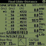
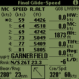
The final glide contains all data necessary for final glide/speed-to-fly calculations. The units for each value on this page are determined by the user through the Units configuration page described below.
Speed and Altitude Values
Soaring Pilot has has two modes of altitude calculation, Speed Optimized and Distance Optimized. The calculation type used is selected from the Final Glide settings window described below. The currently selected mode is displayed in the title area of the Final Glide page as shown in the first two screen shots above. The values in these two columns contain the speed-to-fly (SPEED) and the altitude (Required, Arrival or Delta) needed to glide the distance shown in the lower left hand corner of the screen with the given head/tail wind (HWnd) and McCready (MC) setting.
If set to Distance optimization mode, the top left corner will display "SINK" and represents the current sink being encountered. In this mode, the "*" will be placed next to a recommended value which is based on both the current MC setting as well as the current lift/sink value. If set for Speed optimzation, the top left corner will display "MC" and represents the same value as is entered into the "MC" field on the right side of the screen.
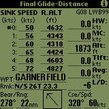

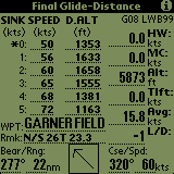
The altitude list defaults to R.ALT or Required Altitude, however it can be toggled to A.ALT(Arrival Altitude) or D.ALT (Delta Altitude) by touching the R.ALT label on the screen. Delta Altitude is the difference between current GPS altitude at the required altitude with a negative value meaning you are under the glide slope. When in R.ALT or D.ALT mode, the altitude displayed includes the "Safety Altitude" setting described below as well as the field elevation if using the internal Soaring Pilot waypoints.
Waypoint Name (WPT)
This field can now be filled in using either the internal Soaring Pilot waypoints or using the GPS waypoints. The current waypoint selection method is configured through the "Use SoarPilot Waypoints" checkbox on the Final Glide settings screen. If this option is checked, whatever waypoint is selected on the Waypoint List Screen will also be shown in this field and used for final glide calculations. If this option is not check then the selected target waypoint on the GPS will be used. In either mode, if no waypoint has been selected, "Not Selected" will be displayed in this field.
Waypoint Remarks (Rmk)
If using the internal Soaring Pilot waypoints, the remarks information for the selection waypoint is displayed in this field.
Bearing & Range to Target (Bear/Rng)
If using the internal Soaring Pilot waypoints, this is the bearing and range to the selected waypoint. If using the GPS waypoints this information is automatically retrieved from the GPS if a compatible GPS is connected to the PalmPilot. If no GPS is connected to the PalmPilot the range can be manually increased and decreased by pushing the up and down scroll buttonson the lower part of the PalmPilot.
Course and Speed (Cse/Spd)
This is the current magnetic course and ground speed of the glider from the attached GPS. If no GPS is connected NOV (No Value) is shown.Head/Tail Wind (HWnd)
The head/tail wind (HWind) can be changed by the left two application buttons on the PalmPilot (Calendarand Phone Icon
). Pushing the buttons increases (
McCready Setting (MC)
The current McCready setting can be changed using the right two application buttons on the PalmPilot (ToDo
and Memo Icon
). Pushing the buttons increases (
GPS Altitude (Alt)
The GPS altitude is parsed from either the proprietary Garmin $PGRMZ (NMEA-183v1.5) or the $GPGGA (NMEA-183v2.0+) sentences. It is then converted as appropriate for the user-seleted units and displayed. By default, this value is the height above Mean Sea Level (MSL). However, it can be changed to be the Height Above the WGS84 Ellipsoid (HAE) using the "Alt. Reference" setting on the Final Glide settings screen.
Thermal Lift (TLift)
The Thermal Lift value is an average lift value for the current thermal if in THERMAL mode or the previous themal if in CRUISE mode. It is calculated from the altitude change every time a new GPS altitude sentence is parsed. It is then converted as appropriate for the user-seleted units and displayed.Current Average Lift(ALift)
The Current Average Lift value is the average of the last 15 Current Lift values. In practice this usually turns out to be approximatly 30 seconds. It is then converted as appropriate for the user-seleted units and displayed.GPS, Logger, Battery Indicators (G, L & B) and Backlight (BL)
The upper-right corner of the window contains status indicators. They give the status of the GPS (if connected), the Logger and the battery:
GPS - The status of the GPS can display the following ways:
- If this status is displayed, it means that the program is not receiving any data correctly through the serial port from the GPS. Either a GPS is not connected or the connection to the GPS is not proper.
- This status means that the program is getting NMEA data but the GPS is not currently receiving enough GPS information to produce an accurate GPS fix.
- GXX or G00 - This status means that the program is getting NMEA data and that the attached GPS has fixed it's position. The GXX status is displayed if the program is receiving NMEA-183 version 1.5 data. If the program is receiving NMEA-183 version 2.0, the G00 status will be displayed with the "00" replaced by the number of GPS satellites currently being used to produce the GPS fix. Note: For an accurate altitude to be produced, a GPS must be receiving information from at least 4 satellites.
Logger - The status of SoaringPilot's internal logger can display the following ways:
- LW - The "LW" status means the the logger functionality is enabled and that the logger is currently in the ON or writing mode.
- LS - The "LS" status means the the logger functionality is enabled and that the logger is currently in the OFF or stopped mode.
Battery - The status of Palm Pilot's battery ways:
- B00 - The "00" will be replaced with the percentage of the overall battery capacity remaining.
-When the battery capacity gets to 10% or less, the battery status will be displayed in inverse video. Backlight - If the backlight is turned on, a
will be displayed in the upper right-hand corner of the final glide page.
Final Glide/Moving Map/Flight Info/Wind Info/Waypoint List/Final Glide Setup/Task Editor Pages Toggle(Find
)
Touching the "Find" (magnifying glass) silk-screen button will toggle between the above windows in a round robin fashion.
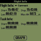
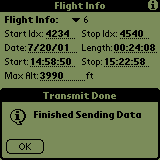
The flight info screen contains a summary of each flight stored in memory. By default, the current flight information is displayed. Other Individual flights can be selected through the drop down menu. In addition, if this screen is displayed while a flight is in progress, the current elapsed flight is shown in the Length field. Using this, the pilot can determine how long he has been aloft.
Flight Selection
The date of the selected flight is show. The format is MM/DD/YY
Start/Stop Times
The Start & Stop times of the selected flight. The format is HH:MM:SS.
Length
The Length of the selected flight. If a flight is in progress, the field will show the current elapsed time for the flight. The format is HH:MM:SS.
Max. Alt.
This is the maximum GPS altitude attained during flight. If the page is displayed while a flight is being logged it will contain the maximum altitude attained during the flight so far.
Task Info
If a task was defined and active when this flight was logged, Start, Stop and Length information for the task is displayed as well. If viewed while the logging is in progress in flight, the Stop and Length values will be automatically updated with the current values.
Graph Button
Selecting this button will display an Altitude vs. Time graph similar to the one below for the selected flight.
Final Glide/Moving Map/Flight Info/Wind Info/Waypoint List/Final Glide Setup/Task Editor Pages Toggle(Find
Touching the "Find" (magnifying glass) silk-screen button will toggle between the above windows in a round robin fashion.
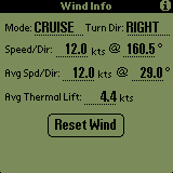
The Wind Info screen contains information about wind and thermal lift strength calculated during thermalling.
Mode
This is the current mode of flight tha the wind calculations have determined that the glider is in. The options are CRUISE or THERMAL. In addition, if the Calculate Wind Info option on the Final Glide settings screen is NOT selected (ie. turned off), this field will contain OFF indicating that wind calculations are not active.
Turn Dir
This is the direction of turn that the wind calculations have determined that the glider is turning.
Speed/Dir
This is the true wind speed and direction (magnetic) calculated from the last 360 degress of turn.
Avg. Spd/Dir
This is the average of the wind speed and direction (magnetic) from the last six 360 degree turns. If the Update Final Glide Headwnd setting is selected on the Final Glide settings screen, these average values are used along with the current course over ground to determine component or vector wind for use in the Final Glide/Speed to fly calculations and displayed in the Headwnd field on the Final Glide screen.
Avg Thermal Lift
As the wind calculations determine that the glider has begun to thermal, the sum of all lift calculations during the entire time the glider is thermalling is maintained as well as the number of lift samples. Once the glider stops thermalling, the average is then caculated using this information and entered into this field. If the Use Avg Lift for MC Value setting is selected on the Final Glide settings screen, this value will also be used to update the MC value on the Final Glide screen.
Reset Wind Button
This button is used to reset all current wind calculations to zero values. At that point, the wind speed and direction will be calculated during the next thermal.
Final Glide/Moving Map/Flight Info/Wind Info/Waypoint List/Final Glide Setup/Task Editor Pages Toggle(Find
Touching the "Find" (magnifying glass) silk-screen button will toggle between the above windows in a round robin fashion.
1. |
2. |
3. |
4. |
5. |
6. |
The Moving Map functionality is basic but has been enhanced to include the following functions:
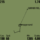
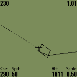
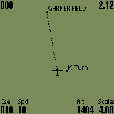
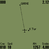
- The screen is laid out in Track Up mode, meaning that the small glider symbol does not actually move on the screen but remains fixed pointing at the top of the screen and approximately 2/3 of the way down. Thus, "UP" is the direction that the glider is currently headed and all waypoints are plotted relative to the glider.
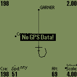
- If the "No GPS Data" status is displayed (screen 5), it means that the program is not receiving any data correctly through the serial port from the GPS. Either a GPS is not connected or the connection to the GPS is not proper.
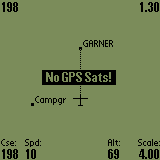
- If the "No GPS Sats" status is displayed (screen 6), it means that the program is getting NMEA data but the GPS is not currently receiving enough GPS information to produce an accurate GPS fix.
- If the "Track Trail" checkbox is checked on the Map settings screen, a track trail point will be plotted for every log point saved. These trail points will be connected together and drawn as a solid line on the map behind the glider. The number of trail points displayed can also be configured on the Map settings screen. However, increasing the number of trail points above 20-25 significantly impacts the map refresh rate. Increase the value carefully. During testing, 20 trail points with a 4 second logger interval provided a trail more than long enough to be very useful for thermal centering. The track trail can be seen in screens 1, 2 & 5 above.
- If a wayoint has been selected on the Waypoints List, a dashed connecting line will then be drawn on the map between the glider symbol and the selected waypoint. If the waypoint is not currently being drawn on the screen, the connecting line will still be drawn in the direction of the selected waypoint. This allows for the connecting line to be used as a directional reference to the selected waypoint. The connecting line can be seen in all of the screens above.
- In addtion, the current bearing and range to the selected waypoint is shown in the upper left (bearing) and right (range) corners of the screen. The range will be displayed in the units selected on the Units setup screen.
- The labels along the bottom of the map are automatically updated. However, the plotting of this information may be turned off by un-checking the "Bottom Label" checkbox on the Map settings screen.
- The number of characters used to plot the waypoint label on the map is configurable through the Map settings screen. The lable length can be set from 12 (max length) down to 0.
- If the "Auto Thermal Zoom" option is checked on the Map settings screen and the wind calculations determine that the glider has begun to thermal, the map will automatically zoom in to the 0.5 nautical mile (or equivalent in other units) to allow the trail plot to be used as a thermal location/centering aid. Once the glider has stopped thermalling, the map will be automatically returned to whatever zoom level it was on before.
Notes:
Create waypoints wisely. The processor on the PalmPilot is not the speediest on the handheld market and the trigonometric calculations required to convert latitudes and longitudes to X,Y plot values are a bit taxing. So, the more items that are being plotted the slower the refresh rate. Above 30 waypoints, it can take a couple of seconds for the screen to refresh after you change the Scale value. Just be patient and it will redraw. I have endeavored to make the display as fast as possible. The only thing that has made a noticeable difference in map performance is the use of CPU overclocking programs such as Afterburner. SoaringPilot will run properly with Afterburner. Overclocking my PalmIII to 22-26 MHz (vice 16) makes a NOTICEABLE difference in map performance. However, it also has an effect on battery life.
Changing Map Scale (Page Up/Page Down Buttons
The page up and pagedown buttons are used to change the scale of the map. The range of the map scale is from 2 to 256 nautical miles with the increments being 2, 4, 8, 16, 32, 64, 128, 256. If the program is configured for statute or metric units, the scale values are converted to the appropriate values.
Waypoint Creation (Calculator Button
)
Touching the "Calculator" silk-screen button will cause a waypoint to be created and displayed at the gliders current location. The waypoint is created with the name "WPXX" where the X's are replaced waypoint slot number. Once created, you may go to the Waypoint List window and modify the various attributes of the waypoint.
Final Glide/Moving Map/Flight Info/Wind Info/Waypoint List/Final Glide Setup/Task Editor Pages Toggle(Find
Touching the "Find" (magnifying glass) silk-screen button will toggle between the above windows in a round robin fashion.
An Exit menu item has been added which will exit the program. This item was added since ALL other silk-screen and hardware buttons (including the power button), except the Menu (
) silk-screen button, are either in use for other functions or have been disabled. This was done intentionally, not to annoy the operator by making it hard to exit the program, but to make it a little more difficult to exit the program accidentally. Allowing the program to exit using the "Home" silkscreen button was too easy to accidentally exit the program and then MUCH more difficult to get the program running again. Trying to do all of this while still safely flying the sailplane would not be an easy thing to do.