Settings Menu

 |
 |
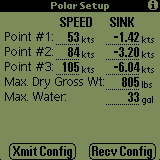
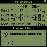
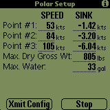
The Polar Setup screen is used to provide the SoaringPilot with the necessary information to approximate the glider's polar. The three point method as described in Helmet Reichmann's Cross-Country Soaring book is used to generate the parameters of a quadratic equation which is used to represent the polar.
V1, V2 & V3 Speeds
Therefore, you have to input three points from the polar. The speeds V1 to V3 should span the spectrum of the polar to achieve a reasonable approximation. It has been recommended that the three points should be the best L/D, Vne & a point approximately halfway between the first two.
V1, V2 & V3 Sink Rates
The sink rates at V1 to V3 can be entered. Using your plane's polar information, you would use the sink rates which correspond to the speeds recommended above. These sink values can be entered as either positive or negative ("-" in front) numbers. However, if you enter positive values, Soaring Pilot will convert them to negative values prior to saving the information. Thus if you enter positive number, change to another page and then change back, the values will be displayed with negative signs in front.
Max. Dry Gross Wt.
This field should be the maximum all-up weight of the glider (including pilot) with no water ballast loaded. The units for this field are set in the Units settings page and shown next to this field. Possible units values are pounds (lbs) and kilograms (kg)
Max. Water
This field should contain the maximum number of either gallons or liters (depending on the Water units selected on the the Units settings page) of water ballast that the glider is capable of carrying.
Xmit & Recv Config Buttons
The buttons allow for the polar and configuration data of Soaring Pilot to be transferred to and from the PalmPilot. The actual use of these buttons is described below in the "Using Soaring Pilot Terminal" section.
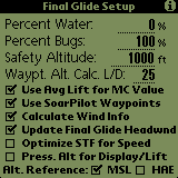
The Final Glide Settings screen allows for setting various options which affect the data that is displayed on the Final Glide screen. It is listed on the Settings menu however, it is also one of the windows which can be moved to through successively touching the Find (
) silkscreen button. This is done to provide easy access to the Water, Bugs & Waypoint Altitude Calc L/D as the pilot may wish to modify these values in flight.
Percent Water
This option allows the pilot to enter the current onboard percentage of the total amount of water that can be carried by the given glider. This percentage along with the Max. Dry Gross Wt. and Max Water values from the Polar settings page are used to shift the polar values appropriatly to account for the additional water weight. This value can easily modified by the pilot using the PageUp(to increase) and PageDown (to decrease) hardware buttons (
) located at the bottom center of the PDA.
Percent Bugs
It is possible to degrade the polar to account for bugs or other performance degrading situations. The bugfactor is used to decrease the L/D at the three polar points entered on the Polar settings screen before the quadratic equation is calculated. A bugfactor of 80%, for example, would degrade the L/D for a given speed by 20%. This value can be easily modified by the pilot using the Calendar(
to increase) and Phone Icon (
to decrease) hardware buttons at the bottom left corner of the PDA. The value of the field will increase/decrease by 10% each time a button is pressed with a range of allowable values between 50% and 100%.
Safety Altitude
The value entered into this field is added to the altitudes displayed on the Final Glide screen allowing for a safety margin or for entering a pattern entry altitude allowance. In effect, this is the minimum altitude at which you want to arrive at the selected destination.
Waypt. Alt. Calc L/D
The altitude value provided for each entry in the waypoint list makes use of this value for the calculation. The default value is "25" however, to make it easy for the operator to modify the value, the field may be modified by pressing the ToDo(
to increase) and Memo (
to decrease) hardware button at the bottom right corner of the PDA.
Use Avg Lift for MC Value
If this option is selected, the MC value will be updated automatically based on the average lift of the last thermal.
Use SoarPilot Waypoints
This option allows the user to use either the waypoints in the attached GPS or to use the internal Waypoint functionality of Soaring Pilot. If the option is selected, the program will ignore the waypoint selection NMEA strings coming from the attached GPS. By doing this, GPS can essentially become just a source of current positional information and not require the pilot to have to interact with two differnent boxes (GPS and PalmPilot). It also allows for the GPS to be placed in a location for optimium reception rather than optimium display. Additionally, with the addition of this capability, Soaring Pilot can now be used effectively with the current crop of "clip-on" or springboard (for Visor's) GPS modules which do not have an internal waypoint capability.
Calculate Wind Info
This option allows the user to turn off all internal wind calculations. If the option is unselected it will also unselect the Update Final Glide Headwnd option.
Update Final Glide Headwnd
If this option is selected, the headwind value used for speed and altitude calculations as well as displayed on the Final Glide screen will be updated automatically based on the gliders current course over ground and the most current average wind speed and direction. Using these values, component or vector wind are calculated and used for final glide/STF calculations.
NOTE: This option will only be active if the "Calculate Wind Info" checkbox is selected as well.Optimize STF for Speed
If this option is selected, the speed and altitude calculations for the Final Glide page are optimized for speed otherwise known as Speed-To-Fly (STF). When calculating STF, the lift/sink currently being encountered by the glider does not factor into the calculations.
If this option is not selected, the speed and altitude calculations are optimized for attaining the greatest distance otherwise known as Final Glide. When calculating Final Glide, the current lift/sink being encountered by the glider as well as the current MC setting are used to help determine the recommended speed.
Press. Alt for Display/Lift
If enabled, pressure altitude data will be used for both altitude displays as well as lift calculations. Note that if "GPS" is selected on the NMEA/Port settings screen, the GPS altitude is also saved as the pressure altitude for compatibility with some flight display programs. That makes this option useful only when connected to a logger/vario outputting pressure altitude.
Alt. Reference
The Altitude Reference option allows for configuring to display either MSL(Mean Sea Level) or HAE (Height Above WGS84 Ellipisoid) for GPS altitude. The default is MSL.
Final Glide/Flight Info/Wind Info/Waypoint List/Final Glide Setup/Moving Map Pages Toggle(Find
Touching the "Find" (magnifying glass) silk-screen button will toggle between the above windows in a round robin fashion.
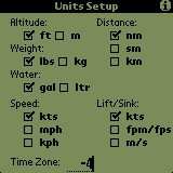
Units
The Units option allows for the setting of the units displayed on other screens. The units for each display are shown in the table below:
Sink Setting:
(Polar Setup)Time Zone
The Time Zone option allows you to enter the numeric designation of your current timezone. This configuration will then be applied to the display of the Start and Stop times on the Flight Info page. The value entered should be negative "-" for West of the Greenwich meridian.
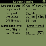
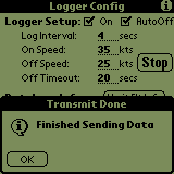
The logger configuration screen of the SoaringPilot allows for configuring various information for the logger. The values shown in the above window should work well for most gliders. The Log interval of 4 seconds produces a relativly smooth trace and, with the current logger database size, would allow for logging over 8 hours of flight time in approximately 500K of the Palm's memory.
Logger Setup
- "On" Checkbox - If checked, the logger will start/stop based on the settings below
- Log Interval - Interval between saving positions
- On Speed - Speed at which the logger will automatically begin saving positions
- Off Speed - Speed at which the logger will automatically stop saving positions if the "Off Timeout" value has expired.
- Off Timeout - Time in seconds which must elapse with the speed below the "Off Speed" value before the logger will automatically stop.
- "AutoOff" Checkbox - If this is unchecked, the "STOP" button will be active and the Off Speed and Off Timout values will be blanked and not editable. This item allows for the logger to start automatically but require that it be stopped by the operator. This allows for situation where the gliders airspeed will be normal but the actual groundspeed may drop to near zero. Flying wave would be an example of this situation. This checkbox can be turned on and off while the logger is functioning without problem or affecting the log.
Database Info
- "Xmit Flt Info" Button - Selecting this button will send ALL flight information to the serial port at 8N1 and the speed defined in the Port Configuration. The data will be output in IGC format with separate headers for each flight. When the transmission of the track data is complete the following status window will be displayed:
Note: Individual flights can be output from the Flight Info page.- No. of Flights - Number for flights being currently being stored
- No. of Posits - Total number of positions being stored
- "Del" Button - Selecting this button will remove all positions and flights from the logger database.
Final Glide/Logger Configuration Pages Toggle(Calculator)
Touching the "Calculator" silk-screen button will toggle between the Final Glide and Logger Configuration windows.
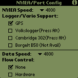
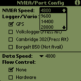
The NMEA/Serial Port Configuration screen allows the operator to configure the settings used for the serial port on the PalmPilot. In addition, initial support has been added for specific Logger/Vario's which output pressure altitude information. Additional support for these devices will be added in later versions.
This pulldown list allows the selection of the serial port speed to be used when receiving NMEA data from a GPS. The standard speed, as defined by the NMEA standard is 4800. However, the operator is given the option of various speeds in order to accomodate more situations or configurations.
Current support is only for pressure altitude parsing from the Volkslogger and Cambridge 302. Additional information will be parsed in later versions. If "GPS" is selected, the GPS altitude will be saved and outputted in the pressure altitude fields. This allows for compatibility with some display programs. The Borgelt B50 is not currently supported as it does not output pressure altitude in an NMEA-type string.
NOTE: The Volkslogger and Cambridge support have not been tested with live instruments. I have used limited recorded/live data from a Volkslogger however the Cambridge support is only from the published dataport documentation.
This pulldown list allows the selection of the serial port speed to be used when sending or receiving all information other than NMEA data from a GPS. This allows for a MUCH higher speed to be selected for this data. Using a faster speed reduces the transfer time for flight and waypoint data SIGNIFICANTLY!
This option DOES NOT affect the serial port connection for receiving NMEA data from a GPS. The NMEA-183 (1.5 & 2.0) standard and most GPS's do not support flow control. This setting will therefore be used for the transfer of Configuration, Polar, Waypoint & Flight data only. It is suggested that Hardware flowcontrol be used for speeds of 9600 or greater. Clean transfers to/from the PalmPilot have been accomplished at up to 115,200!
NOTE: If using a Handspring PDA, hardware flowcontrol is not supported by the PDA. Therefore, clean data transfers will normally not be possible above 4800.
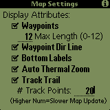
The Map Settings screen allows for the user to configure whether and how items are plotted on the Moving Map Page.
Display Attributes
- Waypoints - If this item is checked, then all waypoints which are within the current zoom radius will be plotted on the moving map.
- Max Length (0-12) - The number of characters used to plot the waypoint label on the map is configurable through this setting. The lable length can be set from 12 (max length) down to 0. If 0, no labels will be drawn.
- Waypoint Dir Line - If a wayoint has been selected on the Waypoints List, a dashed connecting or direction line will then be drawn on the map between the glider symbol and the selected waypoint. If the waypoint is not currently being drawn on the screen, the connecting line will still be drawn in the direction of the selected waypoint. This allows for the connecting line to be used as a directional reference to the selected waypoint.
- Bottom Labels - The labels along the bottom of the map are automatically updated. However, the plotting of this information may be turned off by un-checking the "Bottom Label" checkbox.
- Auto Thermal Zoom - If this option is checked and the wind calculations determine that the glider has begun to thermal, the map will automatically zoom in to the 0.5 nautical mile (or equivalent in other units) to allow the trail plot to be used as a thermal location/centering aid. Once the glider has stopped thermalling, the map will be automatically returned to whatever zoom level it was on before.
- Track Trail - If the "Track Trail" checkbox is checked on the Map settings screen, a track trail point will be plotted for every log point saved. These trail points will be connected together and drawn as a solid line on the map behind the glider.
- # Track Points - The number of trail points displayed can also be configured by entering a value here. However, increasing the number of trail points above 20-25 significantly impacts the map refresh rate. Increase the value carefully. During testing, 20 trail points with a 4 second logger interval provided a trail more than long enough to be very useful for thermal centering. The track trail can be seen in screens 1, 2 & 5 above. NOTE: Currently there is an anomoly in the plotting of the track trail which sometimes causes the trail plot to become skewed. I will attempt to correct this in the next version however, the plot fixes itself on the next map update.
The information in these fields is used for outputting flight data. The data is output in the appropriate IGC lines.