Waypt/Task Menu

 |
 |
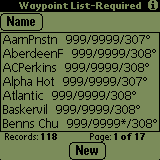
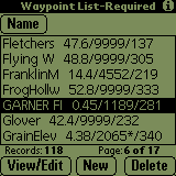
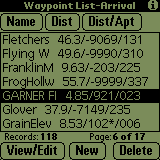
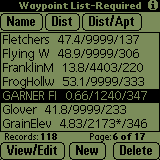
The Waypoint List screen allows you to see all of the waypoints in the database
as well as sort the waypoints in various ways. The list may be scrolled a page
at a time using the PageUp/PageDown buttons (![]() )
on the PalmPilot. In addition to showing the name of the waypoint, when Soaring
Pilot is connected to and receiving data from a GPS, the bearing and range from
the glider to each waypoint is shown. In addition, either the Required or Arrival
altitude, depending on which option is selected on the Final Glide page will
be displayed for each entry. The currently selected altitude option is also
shown in the title bar of the waypoint list.
)
on the PalmPilot. In addition to showing the name of the waypoint, when Soaring
Pilot is connected to and receiving data from a GPS, the bearing and range from
the glider to each waypoint is shown. In addition, either the Required or Arrival
altitude, depending on which option is selected on the Final Glide page will
be displayed for each entry. The currently selected altitude option is also
shown in the title bar of the waypoint list.
The waypoint list can be sorted three ways:
- Name - The first time the name sort button is selected, the list will be resorted with the names in ascending alphanumeric order (0-9 then A-Z). If the name button is selected again, the list will then be re-sorted in descending alphanumeric order. Subsequent selection of the name button will toggle between the two sort orders.
- Dist - If the Dist sort button is selected, the list will be sorted by the current distance values with the closest waypoints at the top of the list.
- Dist/Apt - This sort button is similar to the Dist button however it doesn just sort by distance. In addition, it first sorts the list putting all waypoints marked as either "Airport" or "Land" at the top then it sorts by distance. Using this sort method, the list becomes a Closest Landing Site or Emergency Landing Site list.
When SoaringPilot is first started, the Dist and Dist/Apt sort options will not be available for approximatly 30 seconds depending on the number of waypoints. This is shown in the first and second screens above. During this time, the altitude, distance and bearing values for all waypoints are being updated. Once this initial re-calculation is completed, the other two sort option buttons will be displayed. This shown in the third and fourth screens above. Once the intial re-calculation is completed, only the currently displayed waypoints will be recalculated. If the list is scrolled up or down, the values will be recalculated just after the new list of seven items are displayed.
NOTE: Currently, the waypoint list values are not recalculated when the list is not being displayed. Thus, when switching to the waypoint list from another screen, allow approximately 5 seconds for the values to re-calculated and displayed.
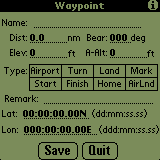
As shown in the first screen above, if no waypoint is selected, only the New button will be displayed. Once a waypoint is selected though, the other two buttons will be shown. Selecting the New button displays the empty waypoint screen shown below. The user can then enter the appropriate information for the new waypoint. If the Save button is selected, the new waypoint information will be saved to the waypoint database. If the Quit button is pressed the new information will be discarded. In addition, if the Name field is blank and the Save button is selected, the waypoint information will NOT be saved.
Once a waypoint is selected, this button will become available. If selected, the waypoint edit screen will be displayed with the selected waypoints information filled in. This is shown in the screen below. The user can then modify the waypoint information as necessary. If the Save button is selected, the waypoint information will be saved to the waypoint database. If the Quit button is pressed the new information will be discarded. In addition, if the Name field is blank and the Save button is selected, the new waypoint information will NOT be saved.
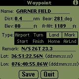
The fields in the waypoint edit screen are:
Name
The Name of the waypoint.
Dist
The current distance to the waypoint
Bear
The current magnetic bearing to the waypoint
Elevation
The Elevation field should contain the actual elevation of the waypoint in MSL. If this waypoint is selected, this value will be used in all Required Altitude calculations.
A-Alt
Current arrival altitude for the waypoints
Type
One or more of the type designators may be selected for the waypoint. The options are:
- Airport - Airfield with hard runway(s)
- Home - The Home Point
- Land - Possible glider landing site
- Start - Start point
- Finish - Finish point
- Turn - Turnpoint
- Mark - Mark point
- AirLnd - Airport or Landing site. This option will be set automatically if either Airport or Land are selected. If neither of these are selected but the AirLnd type is selected, it will be unselected prior to saving the information to the waypoint database.
Remarks
Additional amplifying remarks for the waypoint.
Lat/Lon
The Lat & Lon fields show the latitude and longitude of the waypoint. The format of each value is shown next to the respective fields. The information MUST be entered using these formats. Other formats will not be recognized and could cause problems with the proper operation of the program.
The Delete button removes the currently selected waypoint from the database.
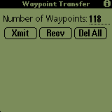
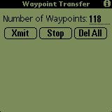
The Waypoint Transfer screen allows you to upload and download waypoints to/from Soaring Pilot. The actual use of this screen and transfer of the waypoints is described in detail below in the "Using Soaring Pilot Terminal" section. You can also easily remove all waypoints currently stored in the waypoint database by clicking on the "Del All" button.
Touching the "Find" (magnifying glass) silk-screen button will toggle between the above windows in a round robin fashion.